A History of the Evans / Yeatman Mill
ca. 1714-1960
by David Hawk
By 1714, John Evans Sr. would have already been familiar with his future mill site as it was only three miles northeast of the Penny Acre residence where he had lived for over a decade. The mill site, at the confluence of the Middle and East Branches of the White Clay Creek, was partially in William Penn Jr’s Stenning Manor and partially in land owned by the London Company. There were no known settlers in the area at the time.
Figure 1 Topography of the Evans millsite, showing the Stenning Manor boundary [1] and elevation levels along the creek.
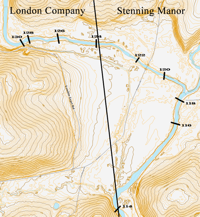
The site had obvious appeal as a mill site because of its topography. Evans would have noted that the Middle Branch provided an ample flow of water year around with a drop of almost 16 feet in less than a mile, and the bend in the creek would have allowed that fall to be captured in a much shorter mill race.
Evans’ prescience about this mill site paid off in many ways over the next two centuries. The mills built here powered the Evans family’s fortunes for several generations and provided the nucleus for a community of his fellow Welsh Baptists. Many members of the Welsh Tract Baptist Meeting south of Newark (where Evans was an Elder [2]) bought land and moved up here after the mill was built, and in 1725 the Evanses donated the land for the Baptist Meeting House.[3] In the following century, the mill site was owned and operated by several generations of the Yeatman family. It was still operating well into the 1950s and was one of the longest-running mill sites on the White Clay Creek.
Figure 2 The original configuration of the grist and saw millsite. Note all elements of the millsite were located east of the Stenning Manor line.
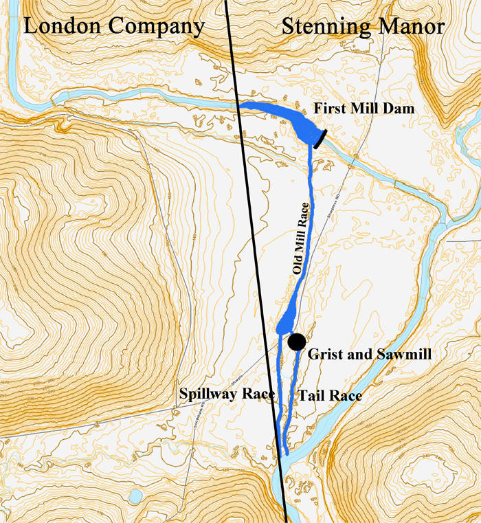
John Evans Sr. purchased 100 acres of William Penn Jr’s Stenning Manor tract to the east in 1714 [4] and probably constructed his grist and saw mill shortly thereafter.[5] The mill dam would have been placed far enough downstream so that the mill pond would not have backed up onto London Company land to the west. This dam and mill race therefore only captured about ten of the potential sixteen feet of fall, but given the quantity of water available, that would have been more than adequate. This first mill race became known as the “Old Mill Race”. [6]
In 1722, John Evans Sr (or possibly John Evans Jr) surveyed a 200-acre tract of land immediately to the west in lands owned by the London Company.[7] Another dam was built on this second tract to power a fulling mill that was constructed near the Old Mill Race on the first tract. A "New Mill Race" was dug to carry water from the new dam to the fulling mill, and the tail race emptied into the Old Mill Race. This new dam captured the remaining six feet of fall for the site.
John Evans Jr’s estate inventory from 1738 shows that the grist mill was a merchant flour mill, not merely a corn grist mill. The inventory listed a cooper shop for making flour barrels as well as a quantity of fine flour [9]. Flour was somewhat of a luxury item and would have been sent into the cities rather than consumed locally. The mill would probably also have ground corn for local consumption, both by people and livestock. Merchant mills were much more lucrative than corn mills, and this is what drove the Evans family's wealth for several generations.
John Evans Jr preceded his father in death in 1738, but by that time he owned both mills. He bequeathed the “grist mill and appurtenances” to his eldest son John (ten years old at the time, later known as John Evans Esq), and “my fulling mill and houses, tenters, tenter yards, and all the implements belonging to the same” to his second son Evan [10]. As neither son was of age, the management of the mills, as well as their income, was left to his widow, Jane Evans, for at least a decade, and possibly much longer.
John Evans Jr, Jane Evans, John Evans Esq, and Evan Evans are all known to have been slaveholders. When John Evans Jr died, his will listed “1 negro lad, 1 negro woman, two small children”, and it is unknown what role, if any, they played in operating the mill. The 1780 Slave Register lists nine people enslaved by John Evans Esq and six by Evan Evans. John Evans Esq’s slaves likely operated his mills while he resided in Philadelphia, and Evan Evans’s slaves likely operated the fulling mill.
Figure 4 1792 Reading Howell Map of Pennsylvania (detail)
It is not known if any of the Evans family were themselves millers, but as the family grew wealthier, they spent more and more of their time elsewhere [11] and would have left most of the day-to-day work to employees, enslaved people, or tenant millers.
The water-powered spinning mills and weaving mills of the Industrial Revolution gradually obsoleted the medieval fulling mill technology, and it is unknown how long the Evans fulling mill operated. The fulling mill dam is mentioned in the metes-and-bounds of the 1794 deed, and the metes-and-bounds of an 1811 deed [12] included the dam and the mill pond above it. There was another fulling mill that advertised for a Fuller in Chandlersville (now Landenberg) two miles to the north in 1820. But at some point, the fulling mill was abandoned, and it is likely the waterpower sat unused until the 1880s.
Yeatman Era
After John Evans Esq died, the mill property passed on to his nephew Samuel Evans who lived in Lancaster. After Samuel died in 1805 [13] it went through a succession of owners before being purchased by John Yeatman in 1829 [14]. Yeatman, a Quaker, was the first of three generations of Yeatmans to own and operate the mill. After John, the mill was inherited by his son Marshall Yeatman, and then by his grandson John C. Yeatman.
A sale ad for the mill from 1826 in the CCHS Clipping Files describes the grist mill as having two runs of stones, one of which was Buhr stones. Buhr stones were imported from the Marne Valley in France and were used in the production of fine flour for the merchant trade. The other run of stones would have been common millstones for grinding corn for feeding livestock (and local people for whom wheat flour would have been a luxury).
The 1870 census record describes the grist mill as in operation the full year and producing $12,000 in income, 80% of that from flour. The grist mill was still powered by a wooden overshot wheel. The saw mill operated only six months of the year and produced about $800 in income, but was powered by a modern turbine.
The 1880 census reported that flour production had increased by 25% over the 1870 numbers.
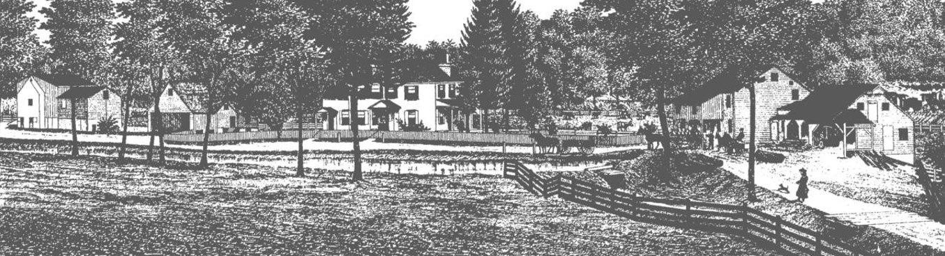
The above drawing is from Futhey & Cope (1881) [15]. The mill race enters from the left and the grist mill and saw mill are on the right. The lower mill pond is in front of the Evans/Yeatman House at the center, and there is a spillway to the right just below the horse and wagon. The barns and other outbuildings are to the left. Note that the mill race and pond are still at ground level.
1880s Mill Race Reconfiguration
Silt is the bane of any mill, and by the 1880s the Old Mill Race and dam would have silted up and diminished the water power at a time when demand for the mill’s services was increasing. John C Yeatman undertook an extraordinary project to revitalize his mill. From a newspaper clipping dated 1888 [16] in the CCHS files:
John Yeatman has 20 men at work on his mill race cleaning it & adding ½ mile to length [17]. Also making repairs to mill.
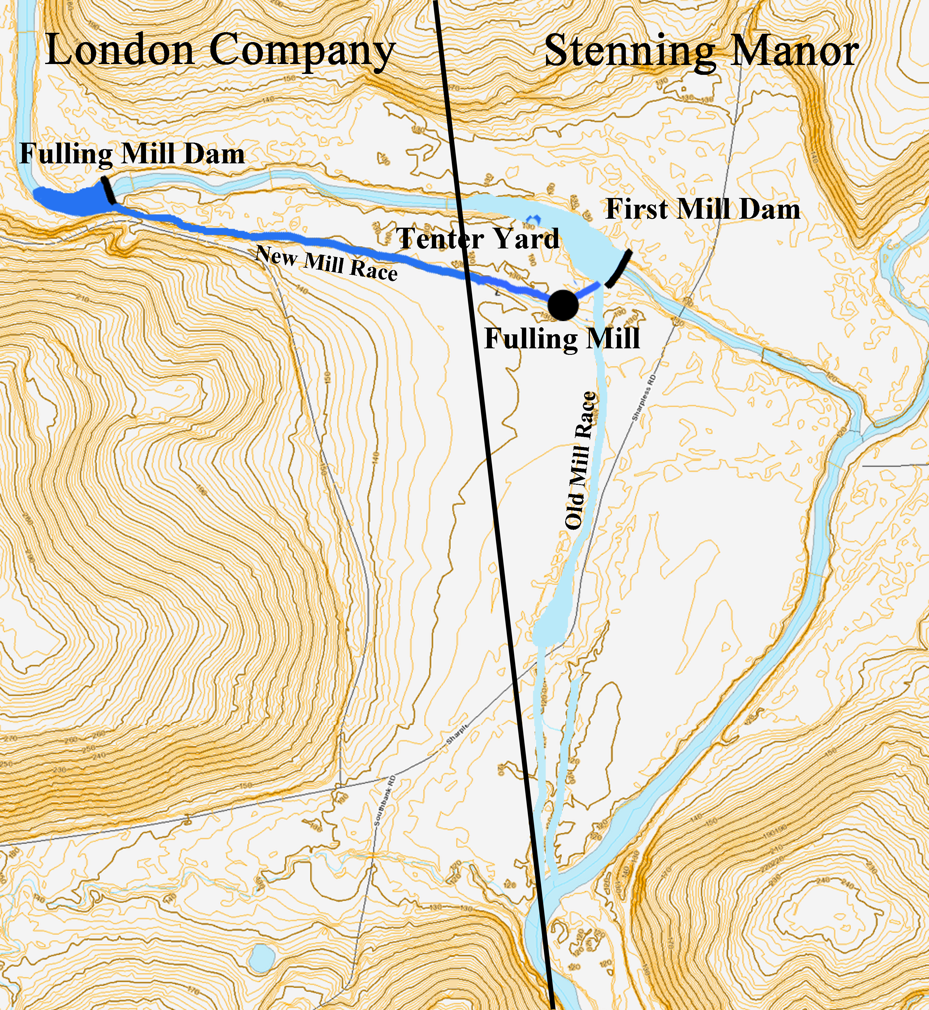
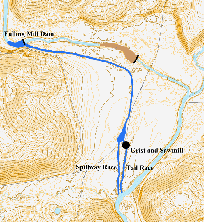
Yeatman utilized the unused upstream fulling mill dam and New Mill Race to accomplish this. The water level at the fulling mill dam was about 6 ft higher than the water level at the silted-in dam. The New Mill Race was cleared out and extended down to connect into the Old Mill Race.
Figure 5 The 1880s reconfiguration of the mill site. The New Mill Race has been combined with the Old Mill Race and the original grist mill dam abandoned.
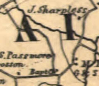
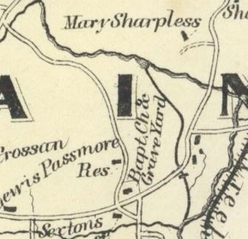
The maps below show this change. The 1860 and 1873 maps still show the mill race in its original (ca. 1715) configuration. Neither map shows the unused fulling mill race. The 1883 map shows the reconfigured mill race.
1860 Kennedy Map
1873 Witmers Map
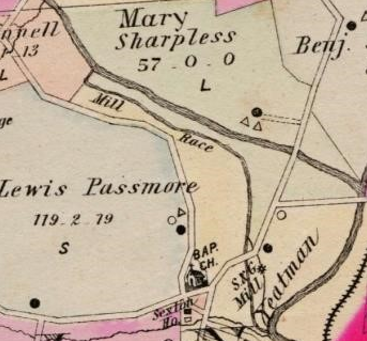
1883 Breous Map
The configurations of the millrace as seen on 1860, 1873, and 1883 maps
The result of this reconfiguration was to raise the water level in the Old Mill Race by about six feet - this would have been above ground level. To accommodate this, berms were built along both sides of the combined mill race as well as the mill pond down by the mill (almost a mile of berms in all). A new concrete spillway for the mill pond down at the mill was constructed as well as the penstock carrying water from the mill pond under the road to the mill.
The above photo, taken from a similar vantage point to the Futhey & Cope drawing, shows the new berms and spillway after the mill race extension was completed. The berm is the horizontal dark line just behind the top of the large tombstone extending from the left edge of the photo almost to the grist mill. The arrow points to the top of the berm at the spillway.
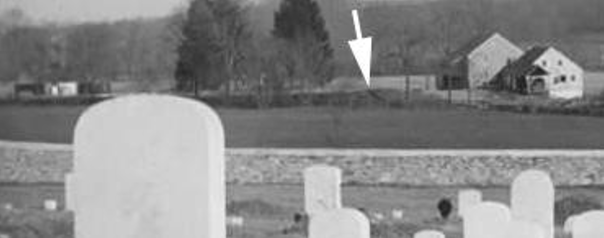
The extensive use of berms would have left the mill site extremely vulnerable to flooding (not to mention groundhogs). Overtopping a berm could have caused a severe washout. For this reason, a concrete headgate was built up by the dam that could be closed during floods, and the concrete spillway down by the mill incorporated a floodgate and a drain that could be opened to quickly lower the water level in the millrace and millpond. The remains of much of this infrastructure can still be seen today.
Dayett Mill
John C. Yeatman sold the mill to Ernest T. Brown in 1908[18] who in turn sold it to J Sherman Dayett [19] in 1911 [20]. The following appears in the CCHS clippings file from 1916:
Dayett's Mill - formerly Yeatman's, took fire Friday from an accident to the stove & was totally destroyed.
Dayett rebuilt the mill with both grist and saw mill capabilities.[21] In 1997 there were still the remains of a 10 ft wide, 10½ ft diameter Fitz iron water wheel in the mill pit that was probably installed at that time.[22]
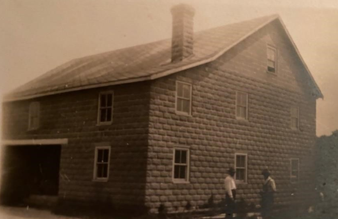
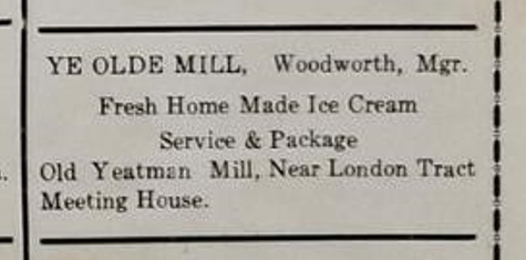
In 1924 the mill was sold to Bruce Woodworth,[23] a miller from Berwick, Nova Scotia, who operated it up into the late 1950s. He also had a dairy farm and made and sold ice cream.[24]
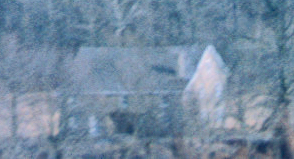
The mill was still standing when DuPont purchased the property in 1960. The photo below was taken from a distance in 1962.
Photo credit: Deb Kraus
List Of Figures
| Figure 1 | Basemap from ChescoViews, retrieved Sept. 2020. ↩ |
| Figure 2 | Ibid. ↩ |
| Figure 3 | Ibid. ↩ |
| Figure 4 | Reading Howell, and Pennsylvania. Secretary Of The Commonwealth. A map of the State of Pennsylvania. [Harrisburg, Pa.: Secretary of the Commonwealth, 1792] Map. https://www.loc.gov/item/80693000/. ↩ |
| Figure 5 | Basemap from ChescoViews, retrieved Sept. 2020. ↩ |
References
| [1] | The location of the Stenning Manor boundary line was determined by examining 1937 aerial photography in which the line can still be seen in the field boundaries. The line is very apparent all the way from Ellicott Rd (south of Avondale) to just north of the Middle Branch, and was extrapolated from there south for this map. See https://whiteclayhistory.info/WBHC/Mills/Stenning%20Manor%20Line/swnf000h.htm. ↩ |
| [2] | Niven, Septimus Evans. Evans, Whitting, Davis, 1st ed. Philadelphia: International Printing Company, 1922, p. 5. ↩ |
| [3] | Ibid. p. 5. ↩ |
| [4] | Ibid. p. 2. ↩ |
| [5] | The construction was certainly before 1722 when Evans purchased the adjacent London Co tract. Had that tract also been available when the grist mill was being built, Evans’s millwright would have taken advantage of the full 16 ft fall of the creek by placing the dam up where the fulling mill dam was later built, run the mill race at a higher contour, placed the mill in the vicinity of where the Sexton’s House now stands, and then used Meeting House Run as the tail race. ↩ |
| [6] | Chester County Deed Books, Deed of Partition between Evan Evans… (1794), Book K2.174 (see p. 181), retrieved from https://searchiqs.com/pachs/ ↩ |
| [7] | Nivin, p. 2. ↩ |
| [8] | Cliff Parker, email message to author, Sept 11, 2019, discussing Chester County Deed K2.174. ↩ |
| [9] | Cliff Parker, Evans Property – London Britain Township. Chester County Archives, unpublished report, 2019, p. 10. ↩ |
| [10] | Niven, p. 10. ↩ |
| [11] | John Evans Jr served as a representative in the Pennsylvania Legislature. John Evans Esq was a lawyer (and Pennsylvania Supreme Court justice) who spent much of his career in Philadelphia. ↩ |
| [12] | Chester County Deed Books, Deed David Eaton & Wife to Jesse Humphrey et al… (1811), Book E3.336, retrieved from https://www.familysearch.org/ark:/61903/3:1:3Q9M-CSNK-9SNV-8?i=186&cat=246232 The metes and bounds description from this deed was used almost verbatim up until 1960 (good luck finding that gum tree). ↩ |
| [13] | Niven, p. 34. ↩ |
| [14] | Chester County Deed Books, Deed Cassimer Missimer & wife to John Yeatman… (1829), Book B4.420, retrieved from https://www.familysearch.org/ark:/61903/3:1:3Q9M-CSNK-KSQM-3?mode=g&cat=246232. ↩ |
| [15] | Futhey, J. Smith, and Gilbert Cope. History of Chester County, Pennsylvania: With Genealogical and Biographical Sketches (Philadelphia, PA: Louis H. Everts, 1881), opposite p. 334. ↩ |
| [16] | This date is suspect since the results of this project appear on the 1883 Breous Map. Perhaps the correspondent did not get down here very often and it was old news by the time it was published. ↩ |
| [17] | The length of the extension was misstated – the total length of the combined mill race was ½ mile when completed. ↩ |
| [18] | Chester County Deed Books, Deed John C. Yeatman to Ernest T Brown… (1908), P13.109, retrieved from https://searchiqs.com/pachs/ ↩ |
| [19] | Son of the then-owner of what is now known as the Cooch-Dayett Mill located south of Newark, DE. ↩ |
| [20] | Chester County Deed Books, Deed Ernest T Brown & Wife to J. Sherman Dayett… (1911), C14.28, retrieved from https://searchiqs.com/pachs/ ↩ |
| [21] | U.S. Census Bureau (1920). Population, London Britain Township. Retrieved from https://ancestors.familysearch.org/en/LBTP-699/john-sherman-dayett-1865-1956 ↩ |
| [22] | Author’s field notes. ↩ |
| [23] | Chester County Deed Books, Deed J. Sherman Dayett & Wife to Bruce F. Woodworth, L16.106, retrieved from https://searchiqs.com/pachs/ ↩ |
| [24] | Email correspondence from Cathy Sylvester, Bruce Woodworth’s grandaughter, January, 2020. ↩ |