The Stenning Manor Line
Knowing the location of the Stenning Manor Line, surveyed in 1700, is important in establishing a date for when the Evans Mill was built. Evans would not have been allowed to build upon land he did not own. This also applied to the millpond, which would not be allowed to back up onto someone else's' land.
In 1714 John Evans Sr. purchased 100 acres in Stenning Manor from William Penn Jr. [1] In 1722 he and/or his son John Evans Jr. purchased an adjoining 200 acres to the west from the London Company [2]. The deeds for both of these parcels are lost and their boundaries cannot be accurately determined today. Over the long term, the Evanses had no reason to maintain the boundary between these two parcels, and they were merged with several other parcels as the Evans family land holdings increased. The Stenning Manor Line became the New Garden Township boundary when New Garden was formed in 1714, however at some unknown time after 1775 the boundary was changed and all of the Evans land was incorporated into London Britain Township. For these reasons, the original Stenning Manor line between the two parcels is no longer visible in today’s parcel or township boundaries.
Further north, however, many parcels maintained their original Stenning Manor boundary. This line is still apparent in aerial photos taken in 1937 where it can be seen in field boundaries. As can be seen in the two aerial photos below, this line is quite conspicuous over a 3½ mile stretch from the south end of Ellicott Rd almost all of the way down to the Middle Branch of the White Clay Creek. This line can be extrapolated south an additional ½ mile to cover the area of interest at the Evans mill site.
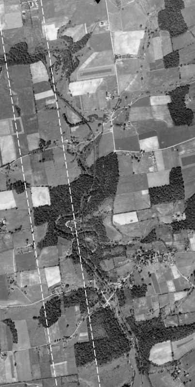
This 1937 aerial photo shows remnants of the Stenning Manor line from the southern end of Ellicott Rd down to about ¼ mile below of Mercer Mill Rd. Dashed white lines have been added on either side of the Stenning Manor line to hilight its location. Figure 1 Penn Pilot Aerial Photo AHK-40-72, 1937.
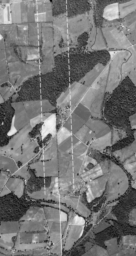
This aerial photo, part of the same series, continues to down below the Evans/Yeatman millsite. The Stenning Manor line is still apparent down to just north of the Middle Branch of the White Clay Creek. The 3½ mile line shown in these two aerial photos is extrapolated an additional ½ mile through the millsite and is shown as a solid white line. Figure 2 Penn Pilot Aerial Photo AHK-40-74, 1937.
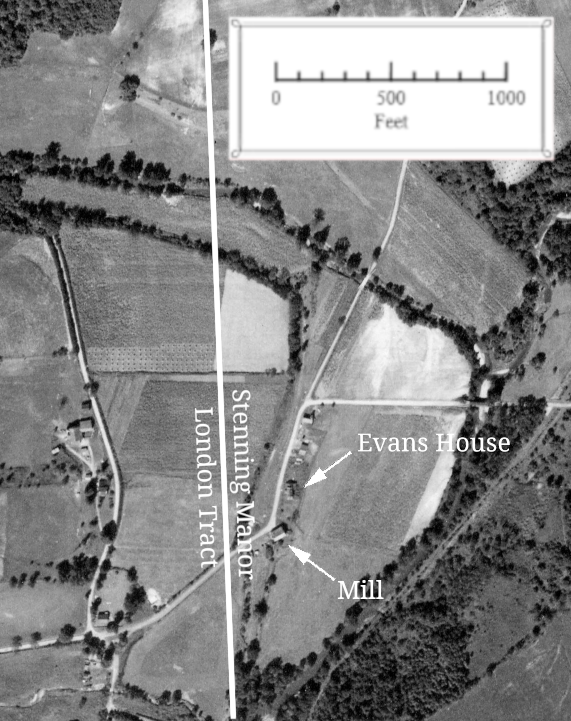
Using known distances visible in the aerial photo near the millsite, it can be calculated that the extrapolated line runs a bit less than 300 ft west of the Evans House [3].
Figure 3 Detail of Evans House and Mill area
The fact that the grist and sawmill and all of its water power infrastructure were built east of the Stenning Manor line indicates that this mill was built before 1722, and probably shortly after 1714 when Evans acquired this 100 acre parcel for this purpose. Had Evans owned the 200 acre tract to the west, it is likely a more optimal millsite would have been built using both parcels.
List Of Figures
| Figure 1 | Penn Pilot Aerial Photo AHK-40-72, 1937. Retrieved from https://https://www.pasda.psu.edu/pennpilot/era1940/chester_1938/chester_1938_photos_tif/. ↩ |
| Figure 2 | Ibid, Photo AHK-40-74. ↩ |
| Figure 3 | Detail of Fig 2. ↩ |
References
| [1] | Septimus Nivin, Evans, Whitting, Davis, (Philadelphia: International Printing Company, 1922). p. 2. ↩ |
| [2] | Ibid. ↩ |
| [3] | The Stenning Manor Line can be approximated in this vicinity by a line starting at the southern end of Ellicott Rd (39°48′8.24″N 75°46′45.61″W) and heading south at a bearing of S4°48′36″E. ↩ |