Rediscovering
the Original Location
of the
Post mark’d West
David Hawk
In 1763, the Penns and Lord Baltimore commissioned Charles Mason and Jeremiah Dixon to finalize the boundaries between their colonies. According to their agreement, Maryland’s northern boundary was to run at a latitude exactly 15 miles south of the southernmost point of Philadelphia. Mason and Dixon deployed their considerable astronomical and surveying skills in an attempt to locate a reference point to meet that requirement accurately. Upon locating that point in a field belonging to Alexander Bryan in Mill Creek Hundred[1], they drove a wooden stake thereafter referred to as the “Post mark’d West”.
Mason and Dixon expended considerable effort in attempting to measure the latitude of Post mark’d West. Their primary instrument for that measurement was a zenith sector telescope[2] built by John Bird, the noted instrument maker for the Royal Observatory at Greenwich. It was a remarkable instrument for its time, although we would not regard it as particularly accurate today, and Mason and Dixon may have thought it more accurate than it actually was. They measured the latitude of Post mark’d West to be 39°43′18.2″N[3], but we should note that this was an astronomical measurement that does not directly correspond to today’s GPS coordinate grid.
Once the Post mark’d West was accepted by Penn’s and Lord Baltimore’s representatives, its latitude became the intended official latitude of what is now the boundary between Pennsylvania and Maryland, as well as part of West Virginia[4]. The original Post mark’d West was only a temporary wooden marker, unlike the permanent stone markers that the Mason and Dixon survey placed elsewhere, and there is no surviving trace of it today[5]. This study aims to identify the original location of the Post mark’d West from information in Mason and Dixon’s Journal and advanced GPS data developed by the Mason-Dixon Line Preservation Partnership (MDLPP).
Determining the Latitude of Post mark’d West
To determine the original latitude of Post mark’d West, we will first explore in some detail the "Secant Method" that Mason and Dixon employed to survey lines of latitude, examine how a mistake in their calculations threw their results off a bit, and then use modern surveys of the positions of the first ten stones to re-create a portion of the original survey. From this, the latitude of the original Post mark’d West can be determined.
Great Circles
A great circle is a circle that exactly bisects the globe. There are an infinite number of great circles. The equator is one, as is any meridian (a line of longitude, i.e., one that passes through both the north and south poles). The shortest path between any two points on the globe is a segment of a great circle. If you start at a specific location and follow a perfectly straight line over the horizon and continue all the way around the earth, after a little less than 25,000 miles, you will return to your starting point having followed a great circle path.
Figure 1 A Great Circle Line (red) and a Line of Latitude (black),
Orthographic projection
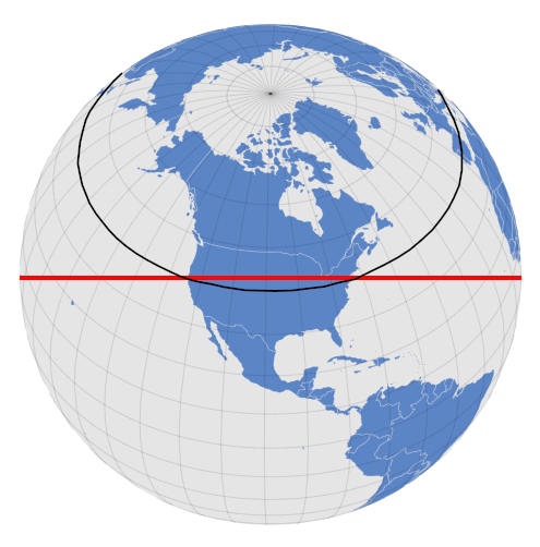
The red line on the globe above is a great circle, exactly bisecting the globe. This particular great circle crosses both the east and west coasts of North America at a latitude of 40º (black line). Note that the 40º latitude line runs south of the great circle line between the two coasts. This view correctly portrays the red line as a straight line and the line of latitude as curved. This differs from how lines of latitude are portrayed on the maps we usually see.
Figure 2 A Coast-to-Coast Great Circle Line (red) and the 40° Line of Latitude (black),
Mercator projection
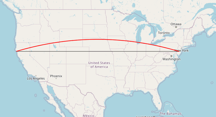
The map above shows the same two lines, but this time on a Mercator projection[6]. As represented on this map projection, the great circle line appears curved, and the line of latitude appears straight. It is not obvious from this map projection that the red line, which is a great circle, is the shortest distance from coast to coast. Any map projection that shows lines of latitude as “straight” lines (as many maps do) will be misleading in this respect.
Other than the above globe, all maps and graphs in this study use the Mercator projection and will suffer from this distortion. Great circle lines, although straight, will appear curved and will be shown in red. Lines of latitude will be shown as straight black lines.
The Secant Method
Once the Post mark’d West had been erected and its latitude determined with the zenith telescope to be 39°43′18.2″N, Mason and Dixon set out to extend a line westward along that degree of latitude to mark the boundary between the Penns’ and Lord Baltimore’s lands. The agreement between them had specified that the boundary was to be a line of latitude, not a great circle line, and the line was to extend 5° of longitude (approximately 265 miles) west from the Delaware River.
You might think the simplest method would have been proceeding straight west, perhaps following a compass heading or using star sightings. The difficulty with this approach is that you need to constantly be correcting your course, or else you will drift slightly south due to the curvature of the Earth. For example, if you started at the Post mark’d West and sighted on a very tall and very distant radio tower that happened to be exactly due west, then walked in a straight line towards it for 12.312 miles, you would find yourself approximately 85 feet south of the desired latitude. Even if you chose shorter segments and changed course more frequently, you would likely still find that you had strayed south of the desired latitude.
To avoid that problem and draw the line of latitude correctly, Mason and Dixon chose instead what is known as the secant method. This involves surveying a great circle trial line with the starting and end points on the intended line of latitude, then calculating and measuring offsets from that trial line down to mark the intended line of latitude. The advantage of the secant method was that, in following a great circle, they only needed to travel in a straight line, and constant course corrections were not needed.
Rather than attempting to survey the entire 5° boundary line in one massive great circle segment, Mason and Dixon instead surveyed multiple shorter great circle segments. They utilized the secant method on each of these segments to determine offsets to the desired line of latitude.
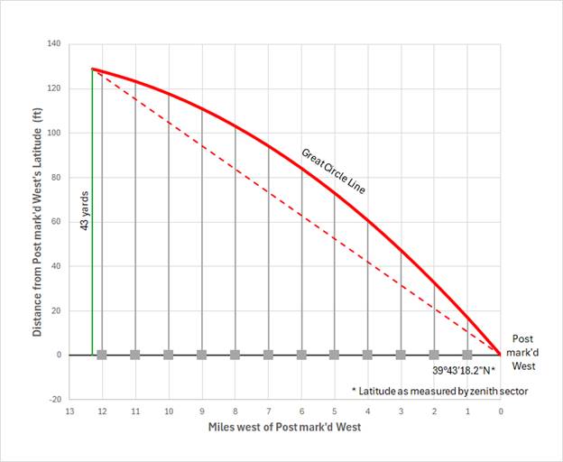
Figure 3 Secant Method: Great Circle Offsets for the First Segment
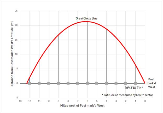
The above graph illustrates the theoretical plan for the first great circle segment of the West Line that Mason and Dixon surveyed. For this segment, they chose a length of 12.312 miles, or 10′50″ of a great circle. This segment length was arbitrary, as the Secant Method works with any length, and Mason and Dixon used different segment lengths later in the survey. Both the start and end points were supposed to be on the desired line of latitude, although Mason and Dixon had means of adjusting the survey if they found they had drifted either north or south of the desired line of latitude by the end of a segment. The largest offset for a great circle segment of this length would have been 21.3 feet. The offset for a marker placed ten miles from Post mark'd West, as can be seen on the above graph, would have been 13.0 feet.
The First Great Circle Segment
Figure 4 Mason and Dixon's First Great Circle Segment
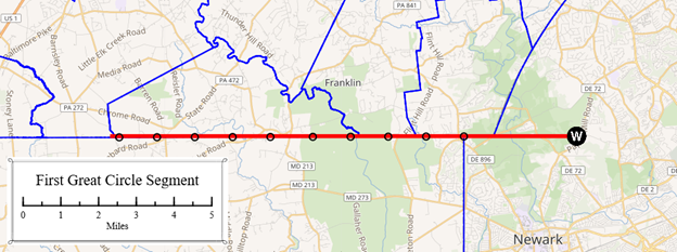
Mason and Dixon started surveying from the Post mark’d West on April 5, 1765, crossed the White Clay Creek on the 8th, and from there followed a line just north of the present-day borders of London Britain, Franklin, and Elk townships. They finished just inside present-day East Nottingham township, slightly beyond where Mount Olivet Road now runs. It took nine days to survey this segment.
Figure 5 Secant Method: Linear Offsets to Correct for Survey Drift
Once they had reached the end of their 12.312 mile great circle segment, Mason and Dixon set up their zenith sector to check their latitude. If all had gone right, they would have once again been back at 39°43′18.2″N. However, after ten days of measurements, they concluded that their great circle line had drifted 43 yards north of their desired latitude (we now know their zenith sector misled them, and, as we shall later see, they had instead drifted 33 feet to the south). They adjusted for this 43-yard error by linearly apportioning it back over the 12.312 miles and adding it to the great circle offsets, as shown in the above graph.
When Mason and Dixon completed their work on this first segment, they believed they had correctly identified the locations for twelve markers, each spaced at a distance of one mile[7], all exactly on the intended latitude of 39°43′18.2″N, 15 miles south of the southernmost point of Philadelphia. In the 260-some years since then, two problems have become apparent: a calculation error in the original journal has been uncovered, and modern GPS technology has revealed the inaccuracies in their zenith sector measurements.
The Calculation Error
The first problem was that Mason and Dixon had made an error in calculating the offsets. This resulted in the stones being placed at the wrong distance from the great circle line.
Figure 6 Excerpt from Mason and Dixon's Journal with Calculation Error.
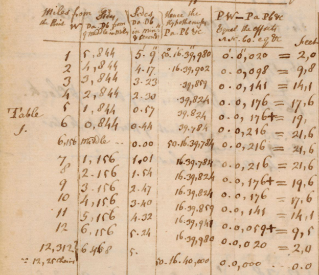
The error can be seen in the table above from Mason and Dixon’s Journal. The first column is the distance from Post mark’d West, and the last column is the calculated offsets for the twelve markers. The error is in the second column, which shows the distance from each mile point to the middle of the 12.312-mile segment (the middle being at 6.156 miles). For example, the distance from Mile 6 to the middle at 6.156 should be 0.156 miles, but it is shown as 0.844 miles. Similarly, the distance from Mile 7 to the middle (6.156) should be 0.844, but it is shown as 1.156. These calculation errors appear in every line of the second column and were used to calculate everything in the columns to the right, so nearly all the figures (except for the middle), including each of the offsets, are incorrect.
Below is the same table with corrected calculations[8].
|
Dist |
Dist from Middle |
|
Hypotenuse |
Offset |
Offset Error |
|||||||
|
(miles) |
(miles) |
(miles) |
(DMS) |
(DMS) |
(DMS) |
(feet) |
(feet) |
(feet) |
||||
|
0 |
6.156 |
0° 5' 25.000" |
50° 16' 40.000" |
0° 0' 0.000" |
0.0 |
|||||||
|
1 |
5.844 |
5.156 |
0° 4' 32.206" |
50° 16' 39.936" |
0° 0' 0.064" |
6.4 |
2.0 |
4.4 |
||||
|
2 |
4.844 |
4.156 |
0° 3' 39.412" |
50° 16' 39.884" |
0° 0' 0.116" |
11.6 |
9.8 |
1.8 |
||||
|
3 |
3.844 |
3.156 |
0° 2' 46.618" |
50° 16' 39.843" |
0° 0' 0.157" |
15.7 |
14.1 |
1.6 |
||||
|
4 |
2.844 |
2.156 |
0° 1' 53.824" |
50° 16' 39.813" |
0° 0' 0.187" |
18.7 |
17.6 |
1.1 |
||||
|
5 |
1.844 |
1.156 |
0° 1' 1.030" |
50° 16' 39.795" |
0° 0' 0.205" |
20.5 |
19 |
1.5 |
||||
|
6 |
0.844 |
0.156 |
0° 0' 8.236" |
50° 16' 39.787" |
0° 0' 0.213" |
21.3 |
21.6 |
-0.3 |
||||
|
6.156 |
Middle |
0 |
0° 0' 0.000" |
50° 16' 39.787" |
0° 0' 0.213" |
21.3 |
21.6 |
-0.3 |
||||
|
7 |
1.156 |
0.844 |
0° 0' 44.558" |
50° 16' 39.791" |
0° 0' 0.209" |
20.9 |
21.6 |
-0.7 |
||||
|
8 |
2.156 |
1.844 |
0° 1' 37.352" |
50° 16' 39.806" |
0° 0' 0.194" |
19.4 |
19.6 |
-0.2 |
||||
|
9 |
3.156 |
2.844 |
0° 2' 30.146" |
50° 16' 39.833" |
0° 0' 0.167" |
16.7 |
17.6 |
-0.9 |
||||
|
10 |
4.156 |
3.844 |
0° 3' 22.940" |
50° 16' 39.870" |
0° 0' 0.130" |
13.0 |
14.1 |
-1.1 |
||||
|
11 |
5.156 |
4.844 |
0° 4' 15.734" |
50° 16' 39.919" |
0° 0' 0.081" |
8.1 |
9.5 |
-1.4 |
||||
|
12 |
6.156 |
5.844 |
0° 5' 8.528" |
50° 16' 39.979" |
0° 0' 0.021" |
2.1 |
2.0 |
0.1 |
||||
|
12.312 |
6.468 |
6.156 |
0° 5' 25.000" |
50° 16' 40.000" |
0° 0' 0.000" |
0.0 |
0.0 |
0.0 |
||||
Erroneous numbers taken from Mason and Dixon’s table are shown in red for comparison. The final column is the difference between the corrected offsets and the ones Mason and Dixon used. It shows, for example, that a hypothetical first marker (one mile from the Post mark’d West) would have been placed 4.4 feet north of its intended latitude due to the calculation error.
Figure 7 Stone mispositioning due to the calculation error
The above graph shows the how these calculation errors resulted in mispositioned stones on this first segment. Generally, the stones nearest to Post mark’d West were placed too far to the north, and stones further west are too far south.
The second problem with this first segment, which only became apparent when better surveying technologies became available many years later, was that their zenith sector was not as accurate as they may have thought it was.
Mason-Dixon Line Preservation Partnership
The Mason-Dixon Line Preservation Partnership (MDLPP) was formed in 1990 to preserve the surviving Mason-Dixon boundary stones. As part of this effort, they have produced an inventory of existing stones with professionally surveyed locations.
Figure 8 Mason-Dixon Line Preservation Partnership Survey
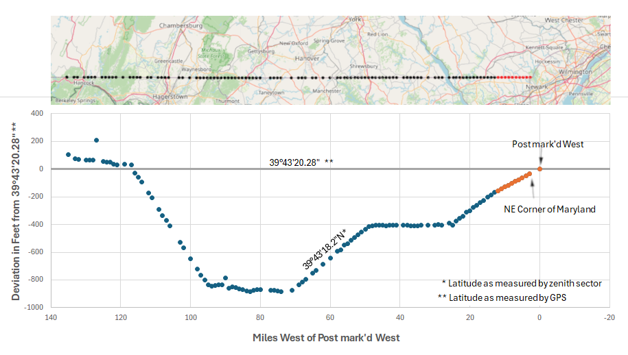
The locations of the stones set by the Mason and Dixon survey are mapped on the above graph as measured by the MDLPP using GPS equipment. Stones that were part of the first great circle segment are shown in red. Mason and Dixon had done their best to position all of these stones at the same latitude as the Post mark'd West (39°43′18.2″N, as measured by their zenith sector), but, as can be seen, their line of latitude was off by almost 900 feet in some places from the latitude of Post mark'd West that, as will be shown below, is approximately 39°43′20.28” in modern GPS coordinates.
Although the stones are off by almost 900 feet in some places, we should recognize that, over more than 130 miles, their work was nonetheless remarkably accurate for its time.As Mason and Dixon worked their way west, they continued to use the secant method with various segment lengths. The locations where they stopped and used their zenith sector to readjust their course are apparent in the sudden bends in the line.
+
Figure 9 The Determination of the Original Latitude of the Post mark'd West
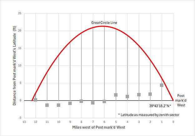
The above graph shows a blue linear trend line fitted to the stones’ GPS locations (as determined by MDLPP) after correcting for the calculation error in the journal. By extrapolating this trendline east to the longitude of the Star Gazer’s Stone[9], we can determine that the latitude of the original Post mark’d West, in GPS coordinates, was approximately 39°43'20.28"[10].
The west end of the trendline, at 12.312 miles, is 162 feet south of the latitude of the original Post mark'd West. This point was determined by Mason and Dixon to be 43 yards (129 feet) south of the endpoint for their first great circle segment after they "corrected" for a supposed northward drift as measured by their zenith sector (see Figure 5 above). This means that their actual drift at the end of their first great circle survey line was only 33 feet to the south (the difference between 162 and 129 feet).
As seen on the above graph, the net result of these zenith sector errors is that all the stones on this segment were misplaced too far to the south. The stone 12 miles west of Post mark’d West was placed approximately 158 feet south of the intended latitude, and the stone at the NE corner of Maryland was placed approximately 39 feet south.A recent determination of the latitude of the southernmost point of Philadelphia found it to be approximately 39°56ʹ26.827ʺ[11]. The difference between that and 39°43'20.28’ is 15 miles and 391 feet. This indicates that Mason and Dixon overshot their objective of placing the Post mark’d West 15 miles south of the southernmost point of Philadelphia by approximately 391 feet, or about ½%. This was a combination of zenith sector errors and chaining errors.
Determining the Longitude of Post mark’d West
The longitude of the Post mark’d West is not as historically significant as its latitude, but Mason and Dixon recorded sufficient information in their journal to allow us to determine its approximate longitude as well.
The Point 15 miles South of the Southernmost Point of the City of Philadelphia is situated in Mill Creek Hundred in the County of Newcastle, in a Plantation belonging to Mr. Alexander Bryan. … It is close by the East side of a small Run, the Head of which is due North distant 5.00 chains.[12]
This passage was cited by William T. Mahoney[13] in 1952 when he placed a modern stone monument in the vicinity of the long-vanished wooden stake erected by Mason and Dixon. The development of LIDAR and GPS technologies since Mahoney did his work allow us to improve upon his location.
Figure 10 The Determination of the Original Longitude of the Post mark'd West (PMW)
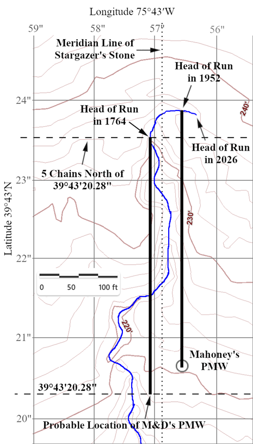
The above map shows how the longitude of the original Post mark’d West can be determined. The course of the small run described in the journal is clearly visible in the 2-foot contour lines of the LIDAR map. That course, augmented by a GPS track of the upper stretch of the run, is sketched in blue. Mahoney’s 1952 marker appears in the lower right, positioned exactly 330 ft (5 chains) south of the location of the head of the run at that time, as indicated by the rightmost solid black line. Today, almost 75 years later, the head of the run has migrated another 30 ft or so further east due to headward erosion. A dotted line has been drawn across the bottom of the map to show the latitude of Post mark’d West, 39°43′20.28″N, as determined previously. As can be seen, this is about 33 ft south of Mahoney’s marker. The discrepancy can be explained by the fact that the head of the run in 1952 was not in the same place that it was in 1764 due to almost two centuries of headward erosion. A second dotted line has been added to show the latitude 330 ft north of 39°43′20.28″N. The point where this line intersects the run would be where the head of the run was in 1764. The longitude of this point is approximately 75°43′57.06″W[14]. The leftmost solid black line represents the 330 ft from the head of the run in 1764 down to the probable location of Mason and Dixon’s Post mark’d West. Note that this longitude is approximately 19 feet west of the longitude of the Stargazer’s Stone, indicating that Mason and Dixon’s due south line drifted a bit over their 14.8-mile survey from their observatory next to the Harlan House.
Conclusion
The probable original location of Mason and Dixon's Post mark'd West is approximately 39°43′20.28″N 75°43′57.06″W. This is approximately 33 ft south and 43 ft west of Mahoney’s Post mark'd West.
Note: This study uses MDLPP's coordinates for the latitude
estimate. Many of them were "professionally surveyed" in the early
1990s, but there have been many improvements in GPS technology since
then. It is possible that a professional re-survey of the first ten
markers could alter the latitude estimate determined by this study.
The longitude estimate uses a coordinate for the path of the stream from a
LIDAR measurement. A professional onsite GPS measurement could alter
that longitude estimate as well.
I would like to thank Paul Lagassé for his considerable editorial assiatance as well as Mike Ott for leading Paul, Tim Barnekov, and myself out for our first visit to the Post mark'd West site.
List Of Figures
| Figure 1 | A Great Circle Line and a Line of Latitude, Base map: AmCharts.com, Rotatable Globe, Orthographic projection, retrieved from https://www.amcharts.com/demos/rotating-globe/. ↩ |
| Figure 2 | A Coast-to-Coast Great Circle Line and the 40° Line of Latitude, Mercator projection, Basemap: USGS National Map. ↩ |
| Figure 3 | Secant Method: Great Circle Offsets for the First Segment. ↩ |
| Figure 4 | Mason and Dixon's First Great Circle Segment, basemap: USGS National Map, Chester County Township Boundary Map. ↩ |
| Figure 5 | Secant Method: Linear Offsets to Correct for Survey Drift. ↩ |
| Figure 6 | Excerpt from Mason and Dixon's Journal with Calculation Error ↩ |
| Figure 7 | Mispositioned Stones due to the Calculation Error. ↩ |
| Figure 8 | Mason-Dixon Line Preservation Partnership Survey. ↩ |
| Figure 9 | The Determination of the Original Latitude of the Post mark'd West. ↩ |
| Figure 10 | The Determination of the Original Longitude of the Post mark'd West. LIDAR basemap retrieved from ChescoViews, https://arcweb.chesco.org/CV4/, June, 2024. ↩ |
References
| [1] | Bryan’s Field is located within today’s White Clay Creek State Park in Delaware. ↩ |
| [2] | A zenith telescope is designed to accurately measure the angle of an overhead star relative to the zenith (the point in the sky directly above the observer). This measurement, when compared to the angle of the same star at a reference location (e.g., the Greenwich Observatory near London) can be used to calculate the observer’s latitude. ↩ |
| [3] | Mason, Charles, and Jeremiah Dixon, with an introduction by A. Hughlett Mason, The Journal of Charles Mason and Jeremiah Dixon, Memoirs of the American Philosophical Society; v. 76 (Philadelphia: American Philosophical Society, 1969), p. 57. https://archive.org/details/JournalOfMasonAndDixon. ↩ |
| [4] | At the time of the Mason-Dixon Survey, Virginia’s land claims still extended into what is now southwest Pennsylvania. Virginia was not a party to the Mason and Dixon Survey, and it did not relinquish these claims and recognize the Mason-Dixon Line as its boundary until 1780. West Virginia separated from Virginia during the Civil War and became its own state in 1863. That portion of the Mason-Dixon Line is now the boundary between West Virginia and Pennsylvania. ↩ |
| [5] | There is a modern monument to the “Post Mark’d West” in the vicinity, but it was was erected in the early 1950s by William T. Mahoney before modern GPS measurements enabled a more accurate location to be determined. ↩ |
| [6] | A map projection is an attempt to represent features of a round globe on a flat surface. Any projection will introduce distortions and will be misleading in some way. ↩ |
| [7] | These points were all initially measured as a distance from the Post mark’dWest. Later, they came back and moved them around 50 ft to the east so that they would instead mark the distance from the NE Corner of Maryland. This small distance makes little difference for the purposes of this study. ↩ |
| [8] | The corrected calculations also benefit from the increased precision offered by modern day computers that do calculations with 15-16 digits of precision. The book of math tables that Mason and Dixon had was only good to seven digits. These tables were state-of-the-art at the time. ↩ |
| [9] | Mason and Dixon surveyed due south from the Observatory at the Harlan House to reach the Post mark’d West. They had previously erected the Stargazer’s Stone due north of the Observatory. If this was all done correctly, the longitude of the Stargazer’s Stone would have been the same as Post mark’d West. ↩ |
| [10] | A trendline omitting the correction for Mason and Dixon’s calculation error would place Post mark’d West 2 ft further north at 39°43'20.30". This is similar to what Robert Mentzer found for his “Stones Line” in his paper “What is the Latitude of Post marked West?”, although he omitted the stone 12 miles from Post mark’d West and included the first stone of the second great circle segment in his calculations. His alternate “Original Line” extrapolation is flawed in that it attempts to fit a straight line to the curved great circle line. Had he fit the “Original Line” data with a curved line rather than a straight line, it would have met the “Stones Line” at Post mark’d West instead of 25 ft to the north. ↩ |
| [11] | Janine Black, and Barry Arkles, “The Mason-Dixon Survey at 250 Years: Recent Investigations.” The Pennsylvania Magazine of History and Biography, 140, no. 1 (2016): p. 96. https://doi.org/10.5215/pennmaghistbio.140.1.0083). ↩ |
| [12] | Mason, Charles, and Jeremiah Dixon, p. 57. ↩ |
| [13] | William T. Mahoney, “The Post Marked West on the Mason‑Dixon Survey,” Delaware History vol. VI, no. 4 (September 1955): pp. 299–306. ↩ |
| [14] | It is impossible to determine exactly how the head of the stream in 1764 eroded down into today’s stream channel. The stream bottom today is about three feet below ground level, and the v-shaped cross-section is about twenty feet wide. This suggests that the longitude could be as much as +/- 10 ft (or +/- 0.13 seconds) of the longitude stated above. ↩ |