The Mason-Dixon and Arc Boundaries
A Descriptive Glossary of the Surveys
by Paul Lagassé
Note: The following descriptive glossary explains terms associated with the Mason-Dixon Line and Arc Boundary. Details that clarify the survey work or otherwise may be of interest are included. It is important to note that many Mason-Dixon and Arc Corner topics have complexities that are beyond the scope of this glossary, and that not all the details associated with the topics are discussed here. Significant terms, such as Northeast Corner (of Maryland) and Southernmost Point (of Philadelphia), are capitalized, even though they might not normally be.
Cross-references to entries within this glossary are indicated by underlining. The alphabetic symbols used for points, locations, boundary markers, and the like are indicated at the beginning of the appropriate entry and in some other useful locations in the text and maps by a letter in white on a black circle, such as the
at the Arc Corner Monument. On the maps, dotted lines represent lines that were not surveyed, and dashed lines are used whenever possible to show surveyed lines that are not modern boundary lines.
The Mason-Dixon Line and Arc Boundary presented surveying challenges that make the actual survey work that their surveyors did as interesting and important as the boundary disputes that led to the surveys. The term surveying tends to call up images of surveyors placing stakes on property lines after having determined the stakes’ locations using measuring chains and a theodolite on a tripod. Or perhaps a more modern surveyor using a modern optical-electronic theodolite with an assistant standing in the distance with a reflector.
The work that Charles Mason and Jeremiah Dixon did was significantly different. Nearly all of the boundary lines they marked were not directly surveyed by them using traditional surveyors’ chains. Instead, they were forced, by the ultimately agreed-upon definitions of the boundaries between the Penn and Calvert lands, to chain in straight lines across the countryside, which was often forested and had to have a pathway cleared through it. Then, after making mathematical calculations (often based on multiple painstaking astronomical observations using state-of-the-art instruments—state-of-the-art for the 1760s), they determined the true boundary’s distance from their straight line and marked it (see Boundary markers, below, and entries for the Arc, North, Tangent, and West lines).
The work done in marking the Arc Boundary in 1701 and 1892 could not, in fact, mark the Arc Boundary. It is impossible to chain across the countryside along a curved line and mark its course, and so the Arc Boundary surveyors were forced to mark equidistant points on an arc (two arcs in 1892) whose location had been determined by other means. The means by which this boundary was marked in 1701 and 1892 were quite different, due to changes in surveying practices and technologies, and are discussed in the Arc Boundary entry.
Arc Boundary
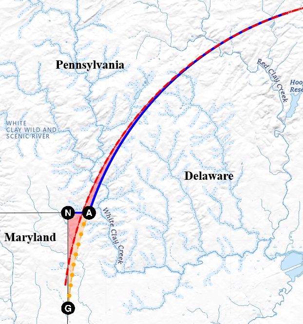
Arc Boundary, also called Delaware Arc and Twelve-Mile Arc — The curved boundary between Delaware and Pennsylvania. It was the result of the exclusion of the land within a circle at a distance of 12 miles from the town of New Castle from William Penn’s grant.
The Court House Circle, centered on the New Castle Court House spire, was used to settle the Penn-Calvert boundary dispute in the mid-1700s but, contrary to popular belief, was not used as the center of the original (or modern) Arc Boundary. The Court House was built after 1701 and could not have been used as the boundary’s center when Taylor and Pierson undertook their survey. Mason and Dixon had nothing to do with the marking of the Arc Boundary, but they did mark the separate Arc Line between Delaware and Maryland, which is centered on the Court House spire.
(2)
The loss of these trees over time led in 1892 to a resurvey of the Arc Boundary headed by W. C. Hodgkins of the U.S. Coast and Geodetic Survey. The inability of the surveyors hired by the Pennsylvania and Delaware commissioners (est. 1889) overseeing the 1892 resurvey to agree on reference points for reestablishing the western portion of the Arc Boundary as surveyed in 1701, led to the creation of the compound modern Arc Boundary, which reconstructed the eastern section from agreed-on reference points from 1701 and created a new arc, Hodgkins’ Arc, in the west that links the end of the recovered eastern section of the Circular Line with a point on an extension of the Mason-Dixon Line that is 12 miles from the spire of the New Castle Court House. Hodgkins used more elaborate survey techniques than were used in 1701, including towers and poles to sight long distances. Triangulation was used to mark the Arc Boundary every half mile, except for the easternmost six miles of the boundary, where a transit and telemeter were used to mark the half-mile chords.
As a result, the modern Arc Boundary is a curved boundary defined by two arcs. The western arc lies to the east (by some 1,200 ft. at its southern end) of the 1701 Circular Line, and the land to its west that was between the 1701 and 1892 boundaries, the Horn, was given to Pennsylvania. This survey also gave the Wedge to Delaware and established the Top of the Wedge Line as the westernmost section of the Pennsylvania-Delaware Boundary. The legal, political, and constitutional issues associated with the creation of the new western section of the Arc Boundary delayed the adoption of the modern boundary until 1921.
Arc Corner Monument
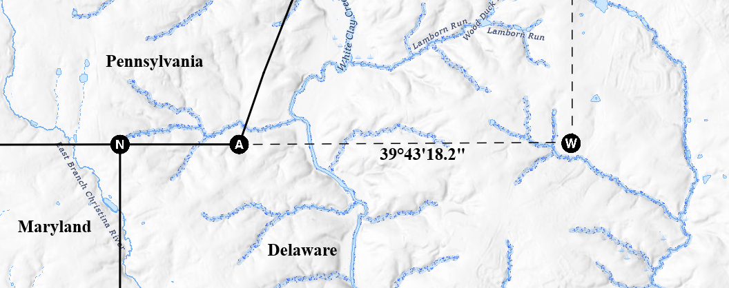
Called the Initial Stone by the 1892 resurvey of the Arc Boundary, it is the southwest endpoint of the modern Arc Boundary and is located at that boundary’s intersection with the Top of the Wedge Line, an eastward extension of Mason and Dixon’s West Line (sense 2). This point is located 12 miles from the New Castle Court House, and is the only point on the modern Arc Boundary that is that close to the courthouse. See maps at Arc Boundary and Post mark’d West.
Arc Line
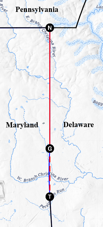
A 1,452-ft. section of the north-south Delaware-Maryland boundary, the middle and shortest section of that boundary. It extends from the Tangent Point north to the southern endpoint of the North Line, and is the portion (arc) of a 12-mile circle that, using the New Castle Court House as its center, extends beyond a line running due north from the Tangent Point. It was marked using mathematically determined offsets from the southern section of the roughly 5-mile line Mason and Dixon surveyed due north from the Tangent Point to the West Line. The longer, northern section of that due-north line is the North Line. The choice of the courthouse as the center of this 12-mile circle was the result of the decisions that led to the settlement of the boundary dispute between the Penns and Calverts, which was finalized in 1760. This new center ultimately influenced the modern Arc Boundary (see also Arc Corner Monument). See map at North Line.
Boundary Markers
(1)
Mason-Dixon Line: The Calverts and Penns had four-sided mile markers with M on the Calvert (or Maryland) side and P on the Penn side (Pennsylvania or Delaware, then the Three Lower Counties) placed by Mason and Dixon in most mile locations; crownstones, with the Calvert and Penn shields from their coats of arms instead of M and P, were placed every 5 miles. Double crownstones, which had Calvert shields on the south and west sides and Penn shields on the other two, were placed at the corner points of the survey – the southwest corner of Delaware (also known as the Middle Point) and the Northeast Corner of Maryland (now the location of the Tri-State Marker). The one surviving double crownstone is located at the Middle Point.
Temporary markers (wood posts) were placed as the boundaries were surveyed and marked, and the permanent markers were placed later by the survey. The double crownstones were placed in November 1768, after Mason and Dixon had left for England. The stones were carved in England from Portland limestone, and are said to be the only U.S. state boundary markers that are made of imported stone. The weight of the markers is unclear. Most sources place the weight of a stone marker at more than 400 lb., though some sources say 500 or 600 lb. The West Line (sense 2) was marked some 230 miles west from the Northeast Corner of Maryland, and temporary markers (wooden posts surrounded by mounded stones or dirt) remained in place westward from mile 133 (Sideling Hill), where mountainous terrain hindered the transportation of the heavy boundary stones. Similar posts were also erected on the tops of 45 ridges from Sideling Hill west. Two stones were placed in locations east of the correct location due to a stream (Mile Marker 80) and a “great stone” (120).
The only exception to the above is the Arc Line and North Line. The Tangent Point was marked by a stone similar to those used in the Transpeninsular Line; the three offsets and the northern terminus of the Arc Line were marked by plain, unmarked stones, as were a location on the North Line and the Northeast Corner of Maryland. All these were placed in 1765 almost immediately after the Arc and North lines were marked. Three mile markers were placed on the North Line in 1766, and one mile marker was placed on the Arc Line. The four original unmarked stones from 1765 were left on the Arc Line. The stone at the Northeast Corner was replaced with a double crownstone in 1768.
In all, 219 (possibly 220) imported stones (including the double crownstones, not including the Tangent Point and Arc Line stones) were placed, from the Middle Point north to the West Line and then west to mile 132. (1 at the Middle Point, 81 on the Tangent Line, possibly a crownstone at the Tangent Point, 1 on the Arc Line, 3 on the North Line, 1 at what is now the Tri-State Marker’s location, and 132 on the West Line. The Penn-Calvert commissioners’ minutes as quoted by Lt. Col. J. D. Graham (see Tri-State Marker and Wedge) in his 1850 report imply that a Mason-Dixon crownstone was placed at the Tangent Point in addition to the Transpeninsular Line–style marker placed in 1765, but Graham found one stone in that location in 1849, and only one stone, the 1765 monument, is currently there.) Mason-Dixon mile markers are most typically numbered on the Tangent, Arc, and North lines beginning with the first mile marker north of the Middle Point, and on the West Line beginning with the first mile marker west of what is now the Tri-State Marker. (This system numbers the Middle Point and Tri-State Marker as zero.)
(2)
Arc Boundary: The modern Arc Boundary is marked at its western end by the Arc Corner Monument, near its eastern end at the Delaware River by the Terminal Monument, and at half-mile intervals between the two. At each of the mile points, of which there are 22, the letters P and D are inscribed on the boundary marker on the Pennsylvania and Delaware sides respectively, the number of miles from the Arc Corner is on the side toward the Arc Corner, and 1892 is on the fourth side. At each of the 22 half-mile points, “1/2” is inscribed instead of the number of miles, and nothing else is marked on the other sides. The 1701 survey of the Arc Boundary used 121 blazed trees as boundary markers, with three blazes on each of the four sides of the trees. The trees were located roughly 0.21 miles from each other (see Arc Boundary).
(3)
Top of the Wedge Line: There are no boundary markers on this line. Less than a mile long, its western end is marked by the Tri-State Marker and its eastern end is marked by the Arc Corner Monument.
Circular Line
see Arc Boundary.
Court House Circle
see Arc Boundary.
Crownstone and Double Crownstone
see Boundary markers.
East Line
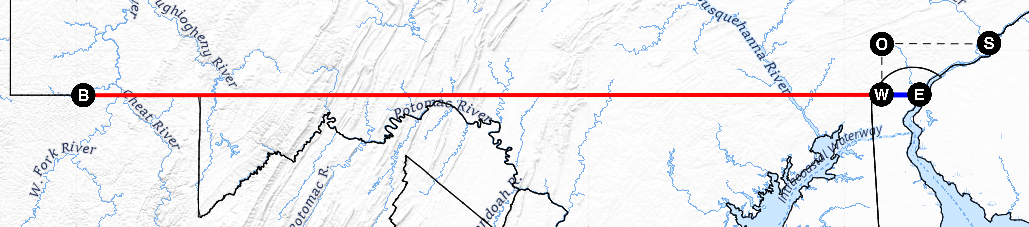
The east-west line on the same latitude as the West Line that was measured by Mason and Dixon starting at the Post mark’d West and ending at the Delaware River, near which they placed a post marked with the letter E
. The length of this line, plus measurements along the West Line, would have allowed Mason and Dixon to determine the western extent of Pennsylvania (defined by William Penn’s charter to be 5 degrees of longitude from the Delaware River) if they had been able to complete the West Line survey. The East Line is not a boundary line, and the former location of the post marked E is not commemorated by any monument. See map at West Line (sense 1).
Graham's Wedge
see Wedge.
Harlan Farm
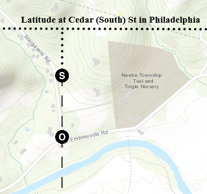
Farm belonging to John Harlan, located about 31 miles to the west of the Southernmost Point of Philadelphia, near Embreeville, Pa., and the Forks of the Brandywine. Here Mason and Dixon relocated their observatory
after the latitude of the Southernmost Point had been determined. The surveyors moved here because surveying 15 miles due south of the Southernmost Point would have put them across the Delaware River in New Jersey. After astronomical observations, they determined the latitude of the observatory at the farm, which they calculated was located about 0.2 mile south of the Southernmost Point’s latitude. They then surveyed due south into New Castle County to a location that they determined, as a result of more than one survey and calculations to account for the difference in location between the Southernmost Point and the farm observatory, lay 15 miles south of the Southernmost Point, and there erected the Post mark’d West. Before their survey south, they erected the Stargazers’ Stone
on the Harlan Farm north of the observatory.
Hodgkins’ Arc
The term used in this glossary for the arc drawn in 1892 during the resurvey of the Arc Boundary in the western section of that boundary; it replaced the portion of the Circular Line that had been there. Benjamin H. Smith and Daniel Farra, the surveyors that the boundary commissioners (est. 1889) engaged, identified four features, extending from the Kennett-Pennsbury boundary east to the Delaware River, that could be used to reestablish the eastern section of the Circular Line. Although a considerable number of features traditionally associated with the original boundary were identified west of the Kennett-Pennsbury location by the inhabitants, Smith and Farra could not agree on these, and no potentially satisfactory evidence was found until after the commissioners had agreed to use a point on an eastward extension of Mason and Dixon’s West Line (sense 2) located 12 miles from the New Castle Court House spire as the western end of the Arc Boundary (see Arc Corner Monument; see also Court House Circle under Arc Boundary). This necessitated surveying and marking a new arc from that point to the Kennett-Pennsbury boundary. W. C. Hodgkins, of the U.S. Coast and Geodetic Survey, was hired in 1892 to resurvey and mark the eastern and western sections, and oversaw the creation of the western arc. Delaware farmers who discovered that their farms were now in Pennsylvania were angered, and the refusal of one of them to pay taxes in Pennsylvania led to a court decision that required that both states and the U.S. Congress ratify the boundary, because the commissioners had created a new state boundary line. The political backlash delayed complete ratification until 1921.
Horn
A narrow, curving, elongated horn-shaped piece of land of about 530 acres that was east of the 1701 Arc Boundary but west of the 1892 Arc Boundary, assigned to Pennsylvania by the commissioners overseeing the 1892 survey. Its base was roughly 1,200 ft. long (not quite the eastern third of the Top of the Wedge Line), and its two sides curved toward an apex roughly halfway up the modern Arc Boundary, to the boundary between Kennett and Pennsbury townships. The commissioners also assigned the Wedge to Delaware. See map at Arc Boundary.
Mason-Dixon Line
(1)
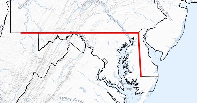
Perhaps best thought of as the Mason-Dixon “Lines,” the Mason-Dixon Line in this sense consists of the Penn-Calvert boundary lines surveyed by Charles Mason and Jeremiah Dixon. With respect to the present-day states, the lines they surveyed form the north-south boundary of Delaware and Maryland and the east-west boundary of Pennsylvania and Maryland and part of the east-west boundary of Pennsylvania and West Virginia. (West Virginia, part of Virginia at the time of the survey, was not Calvert land, but the proprietors agreed to survey the entire southern boundary of Pennsylvania. The threat of native conflict ended the survey prematurely.)
Starting from the southwest corner of Delaware, Mason and Dixon marked the northward Tangent Line (from the Middle Point [southwest corner] to the Tangent Point), the Arc Line, and the North Line, which ends at what is now the Tri-State Marker, the Northeast Corner of Maryland. West from that marker, on a line of latitude, they marked the West Line (sense 2), which they extended some 230 miles into the wilderness, not quite to the end of Pennsylvania’s southern boundary. (The surveying and initial, temporary marking of the West Line [sense 1] began from the Post mark’d West, not quite 3 miles east of the Tri-State Marker and the beginning of the Pennsylvania-Maryland line.)
The boundary lines were surveyed and marked as follows: The Tangent Line (1764; monumented with the imported boundary markers in 1765 to 50 miles, completed 1766), the West Line (to the Susquehanna, 1765; monumented 1766), the North Line with the Arc Line marked as offsets (1765; monumented, 1766), and then the rest of the West Line (1765 to 117 miles temporary [114 monumented], 1766 to 165 [162], 1767 to 233 [230]; monumented 1766 to 65 miles [except 64], 1767 64 and from 66 to 132, the rest left unmonumented). The East Line, which was not a boundary line, was surveyed in 1766 after the West Line. The Middle Point and the intersection of the North and West lines (the Northeast Corner of Maryland, now the Tri-State Marker’s location) were monumented in 1768 after Mason and Dixon had left for England.
Mason-Dixon Line: The colonial boundaries Mason and Dixon surveyed and marked in the 1760s.
(2)
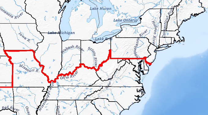
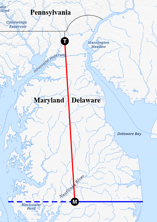
The term Mason-Dixon Line came to be used for a sociopolitical “line” that divided those states where the ownership of human beings was legal from those where it was not. In this sense, it traditionally is the southern boundary of Pennsylvania extended eastward along the Pennsylvania-Delaware boundary and westward along the Pennsylvania-Virginia east-west and north-south boundaries (since 1863, Pennsylvania–West Virginia) and the Ohio River, and then across the Mississippi along an extension of the main southern boundary of Missouri (with the exception of Missouri itself).
This line was a product of the gradual end of legal human enslavement in Pennsylvania and other states to its north and east, a process that began with Pennsylvania’s aptly named Act for the Gradual Abolition of Slavery (1780); a second law, passed in 1847, ended the last vestiges of slavery in the state. The line was extended west to the Mississippi by the Northwest Ordinance (1787), which forbade slavery in the Northwest Territory (located north of the Ohio and east of the Mississippi), and later west of the Mississippi by the Missouri Compromise (1820), which allowed Missouri to enter the Union as a slave state and Maine to do so as a free state while also forbidding slavery in U.S. territories north of main Missouri’s southern boundary (latitude 36°30'N, which lies about 33 miles south of the confluence of the Ohio with the Mississippi). The Missouri Compromise, however, was effectively repealed by the Kansas-Nebraska Act (1854), and declared unconstitutional by the Dred Scot decision (1857).
Mason-Dixon Line: The boundary between free and slave states after 1820.
Middle Point or Transpeninsular Middle Point 
The halfway point between the Atlantic Ocean and Chesapeake Bay on the Transpeninsular Line. Not determined by Mason and Dixon, but used as the starting point for their work on the Tangent Line, it is marked by a double crownstone (see Boundary markers), the only surviving such marker from the Mason-Dixon survey; it was placed in November 1768 after the surveyors had left for England. See map at Tangent Line.
North Line
The northernmost section of the Delaware-Maryland boundary surveyed by Mason and Dixon. It runs due north from the north end of the Arc Line for 3.568 miles to the West Line, intersecting it at the point now marked by the Tri-State Marker. The North Line was surveyed due north from the Tangent Point, a distance of about 5 miles, and the Arc Line was then marked off by offsets from the southern portion of the surveyed line. The North Line was the only boundary line surveyed by Mason and Dixon that could be marked on the ground as it was surveyed (that is, without the need for mathematical calculations to determine the location of the true boundary).
Post mark’d West or Post Mark’d West 
Wooden post with the word West on its west side, placed by Mason and Dixon at the location of the line of latitude, 39°43'18.2"N, that was 15 miles south of the Southernmost Point of Philadelphia. Its location, on Bryan’s Farm in New Castle County (now within Delaware’s White Clay Creek State Park), was determined by surveying and calculation, and its latitude was determined by multiple painstaking astronomical observations. It was the reference point for the surveying of the West Line and for the temporary, but not the permanent, mile markers they placed on that line (see Boundary Markers). See also Harlan Farm. See also map at West Line (sense 1).
Prism Stone 
See Tri-State Marker.
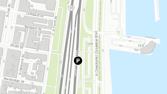
Southernmost Point of Philadelphia 
The boundary settlement between the Penns and Calverts specified that the southern boundary of Pennsylvania would run along a line of latitude lying 15 miles south of the Southernmost Point of Philadelphia. The commissioners overseeing Mason and Dixon’s survey agreed in December 1763 that the north wall of a house on the south side of Cedar Street was the Southernmost Point of Philadelphia (this location, the Plumstead-Huddle House, would now be on South Street, except that it lies under the northbound lanes of I-95), and thus at the latitude from which the surveyors were to measure 15 miles southward. They set up an observatory 37.15 yards northward of this point, and determined (finishing the work in January 1764) that the latitude of the north wall was 39°56'29.1"N. Knowing the latitude enabled them to confirm that the Post mark’d West lay 15 miles south of the Southernmost Point when they moved some 31 miles west to the Harlan Farm.
The Southernmost Point of Philadelphia's present-day location.
Stargazers’ Stone or Star-Gazers’ Stone
Stone placed on the Harlan Farm by Mason and Dixon prior to their survey due south that established the Post mark’d West (which was located 15 miles south of the Southernmost Point of Philadelphia). The stone was set in the longitude of the location of their observatory
Tangent Line 
The line that Mason and Dixon marked between the Middle Point and the Tangent Point. The surveyors did not attempt to survey across the countryside from the Middle Point to the Tangent Point, a distance of nearly 82 miles. Instead, using astronomical observations to keep their line extremely straight, they surveyed from the Middle Point to a location near the Tangent Point, and then, after mathematical calculations and additional surveying, corrected the placement of markers that earlier colonial surveyors had set during two failed attempts to mark the Tangent Line. The failure of colonial surveyors to mark this boundary line during 1761–1763 was what led to Mason and Dixon’s hiring.
Tangent Point
The point on a circle 12 miles from New Castle, Del., that the boundary north from the middle of the Transpeninsular Line (the Tangent Line) touches at a right angle to the radius of that circle. For the purposes of the boundaries between the Penn and Calvert lands, this circle was to be drawn at 12 miles from the New Castle Court House. This was a different center from that used by the Arc Boundary surveyed in 1701, and the location of the Tangent Point was determined in 1761, before Mason and Dixon were hired. Marked by the Tangent Stone (see Boundary markers), it is considered to be the location of Mile Marker 82 on the Tangent, Arc, and North line (the three south-to-north Delaware-Maryland boundary lines surveyed by Mason and Dixon), as it is nearly that distance from the Middle Point.
Top of the Wedge Line
The section of the Pennsylvania-Delaware boundary that lies between the Tri-State Marker and Arc Corner Monument, it marks the northern boundary of the Wedge (as determined by Lt. Col. J. D. Graham). An extension eastward of the West Line (sense 2), Pennsylvania’s boundary with Maryland and a part of its boundary with West Virginia that was marked by Mason and Dixon in the 1760s, it was established by the 1892 Arc Boundary resurvey led by W. C. Hodgkins, but it, along with the modern Arc Boundary, was not officially adopted as the Pennsylvania-Delaware boundary until 1921. See map at Arc Boundary.
Transpeninsular Line or Transpeninsula Line
An east-west line surveyed across the Delmarva Peninsula, from Fenwick Island to Taylors Island during 1750–1751. From Fenwick Island to the Middle Point of the line it forms the southern boundary of Delaware. It was not surveyed by Mason and Dixon, but the Middle Point is the southern end of the Tangent Line they did survey. See map at Tangent Line.
Tri-State Marker
The name used for the boundary stone located at the intersection of the Pennsylvania, Maryland, and Delaware boundaries.
Although some had the impression as time passed that the Arc Boundary (the Circular Line laid out in 1701) intersected Mason and Dixon’s boundary lines at the junction of the West and North lines (the Northeast Corner of Maryland), a thin, roughly triangular piece of land, which became known as the Wedge, separated the Arc Boundary from the North Line. Several early maps clearly showed the Wedge (as part of Pennsylvania), including the 1792 Reading Howell map of Pennsylvania,
Since 1850, when Lt. Col. J. D. Graham published his report on his 1849 survey to replace the missing Mason-Dixon double crownstone (see Boundary markers) that had been erected at the Northeast Corner of Maryland in 1768, two boundary markers, one at the junction of Mason and Dixon’s North and Arc lines, and the other at Northeast Corner of Maryland, have successively had a claim on the name of Tri-State Marker. Both, as it happens, were placed by Graham during his survey.
(1)
Lieutenant Colonel Graham, of the U.S. Corps of Topographical Engineers, was hired by Delaware, Maryland, and Pennsylvania to locate the position of the lost double crownstone at the Northeast Corner and place a new marker there. During his work, he decided that the tri-state boundary intersection was where the Court House Circle (see under Arc Boundary) intersected the North and Arc lines. There he placed a three-sided stone marker, now called the Prism Stone
(2)
At the Northeast Corner of Maryland, the intersection of the North and West lines
, Graham erected a square pillar with M on the south and west sides and P on the north and east sides. This paralleled the arrangement of the Calvert and Penn shields on the lost double crownstone. Not until after the resurvey of the Arc Boundary (1889 to 1892, with the field survey led by W. C. Hodgkins in 1892) was the Northeast Corner first designated as the site of the intersection of the three states’ boundaries and the location of the now mis-inscribed Tri-State Marker (D should be on the east side). The commissioners overseeing the survey agreed to make the Top of the Wedge Line, which extends from the western end of the modern Arc Boundary (see Hodgkins’ Arc; Arc Corner Monument) to the Northeast Corner, the westernmost section of the Pennsylvania-Delaware boundary. The surveying of Hodgkins’ Arc and the acceptance of the Top of the Wedge Line as a boundary line gave the Wedge to Delaware and the Horn to Pennsylvania. However, objections to the survey commissioners’ decision concerning the Horn, which moved some Delawareans into Pennsylvania, led to a court decision over their taxation that required the two state legislatures and the U.S. Congress to ratify the boundary changes. Continuing objections in Delaware delayed full ratification until 1921, at which point the marker that Graham had placed at the Northeast Corner of Maryland in 1849 legally and indisputably became the Tri-State Marker. This also ended any claim that what is now called the Prism Stone had to that moniker. See also Top of the Wedge Line, and the map at Post mark’d West.
See map at North Line for the location of both “Tri-State Markers.”
Wedge
A roughly triangular piece of land between Maryland and the Arc Boundary, south of the latitude of the West Line. The charter for Pennsylvania called for the exclusion from the colony of the land within a circle at 12 miles distance from New Castle.
(1)
Taylor and Pierson surveyed a third of that circle, the Circular Line, from the Delaware River west into what is now Maryland, in 1701 (see Arc Boundary), at a time when William Penn controlled both Pennsylvania and what is now Delaware and when he also was claiming land farther south in what is now Maryland. When Mason and Dixon established the North Line as part of the eastern boundary of Maryland, that line intersected the 1701 Arc Boundary south of the Northeast Corner of Maryland, creating a triangular region of about 310 acres that lay between the 1701 Arc, the North Line, and what is now somewhat more than the western two thirds of the Top of the Wedge Line. This Wedge was claimed by both Pennsylvania and Delaware after Independence. Generally mapped as part of Pennsylvania, it was administered by Delaware.
(2)
Lt. Col. J. D. Graham, in his 1850 report on his survey (1849) to restore the missing Mason-Dixon boundary marker at the Northeast Corner of Maryland, mapped (but did not survey) the southern portion of a new Arc Boundary that was 12 miles from the New Castle Court House (not the horse dike used in 1701); this more than doubled the size of the Wedge, and exceeded his commission, but did not end Delaware’s administration of the area. The commissioners overseeing the Arc Boundary survey of 1892 assigned the Wedge to Delaware and established the Top of the Wedge Line as the westernmost section of the Pennsylvania-Delaware line. The Arc Boundary established in 1892 also gave the land that was east of the 1701 Arc Boundary but west of the 1892 boundary (see Arc Boundary), the Horn, to Pennsylvania. See map at Arc Boundary.
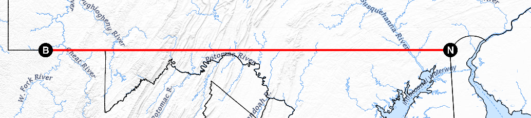
West Line
A term with two different senses, for slightly different distances of the same line surveyed and marked by Mason and Dixon. The West Line was to lie along latitude 39°43'18.2"N, which the surveyors determined was 15 miles south of the Southernmost Point of Philadelphia. The locations where permanent markers were placed diverge from that latitude by no more than 680 ft., a remarkable achievement for the time. The line was to run a full 5 degrees of longitude west from the Delaware River according to William Penn’s charter, but the threat of conflict with Shawnees and Delawares led them to stop at what is now Brown’s Hill
, some 233 miles west of the Post mark’d West and more than 20 miles short of what is now the southwest corner of Pennsylvania. (According to Mason and Dixon’s calculation—recorded in January 1768, after they had completed the survey—5 degrees of longitude at the latitude of the West Line is not quite 268 miles.)
In order to survey the line of latitude that was Pennsylvania’s southern boundary, which due to the earth's curvature is not straight but gently curved, Mason and Dixon surveyed and temporarily marked an adjacent straight line (a great-circle segment) for 12 miles or so. After making astronomical observations to determine their new location’s position relative to the latitude they were to mark, they calculated the distances between the temporary mile markers on the line they had surveyed and the boundary's latitude. They then began the process again from their current location. West of the Susquehanna, they typically surveyed and marked two great-circle segments before making observations and calculating the offsets. They subsequently placed temporary mileposts at the calculated locations on the boundary, later replacing them with permanent stone markers (see sense 2, below).
(1)
The West Line in the first sense is the entire length that Mason and Dixon surveyed westward from the Post mark’d West
(2)
In its second sense, the West Line is the east-west colonial boundary line that was marked by Mason and Dixon, which now comprises the Pennsylvania-Maryland boundary and part of the east-west Pennsylvania–West Virginia (Pennsylvania-Virginia prior to 1863) boundary. Although it was surveyed westward from the Post mark’d West, the West Line in the sense of the boundary of Pennsylvania begins at the Northeast Corner of Maryland, the location now of the Tri-State Marker
Base maps: USGS National Map, USGS Shaded Relief, USGS Hydro