A History of the Arc Boundary
by David Hawk
1681 - William Penn’s Colonies
In 1681 William Penn was granted a large tract of land on the Delaware River to be known as Pennsylvania in partial payment for a debt the King owed his father. To avoid infringing on the downstream colony (now Delaware) owned by the Duke of York (the King’s brother), this tract excluded anything within twelve miles of the town of New Castle. The following year, Penn was also granted the Duke of York’s colony as an additional payment on that debt. When Penn arrived in America his first act was to convene an Assembly to approve an Act of Union that combined the two colonies into one. Since Penn now owned both colonies, the twelve-mile exclusion around New Castle was moot and no attempt at establishing a twelve-mile circular boundary was made at that time.
Penn’s combined colony was initially organized into six counties: Bucks, Philadelphia, and Chester (collectively the “Province of Pennsylvania”); and New Castle, Kent, and Sussex (collectively the “Lower Counties” or “Territories”). Chester County at that time extended from the Delaware River inland only as far west as the Brandywine with its southern border around Naaman’s Creek [1]. New Castle County extended inland far to the northwest and encompassed more than half of present-day Chester County. In these early years, the entire White Clay watershed was considered to be back-country New Castle County and patent and deed descriptions for tracts of land sold there gave the property location as “New Castle County” or “South of the Brandywine”.

Figure 1 Thomas Holme's 1687 Mapp of ye Improved Part of Pensilvania.
Thomas Holme's Mapp of ye Improved Part of Pensilvania is oriented with the Delaware River along the bottom and north to the upper right. The map features the three counties of Chester, Philadelphia, and Bucks as they were then laid out, with the tracts that had been sold and their owners. New Castle County, not one of the Pennsylvania counties, is to the left and does not show tracts and owners. The boundary line between Chester and New Castle Counties at this time does not attempt to conform to a twelve-mile circle but instead runs up along the east branch of the Brandywine. The White Clay watershed is off the map to the left and was entirely within what was then New Castle County. The inset map is at the same orientation as the main map and shows today's county boundaries and has been extended to the left to show more of present-day New Castle and Chester counties. A red circle has been added at the lower left to indicate the approximate position of the twelve-mile circle.
By 1701 Penn’s “Holy Experiment” seemed to be unraveling. The Lower Counties, populated primarily by Dutch settlers, were increasingly at odds with the Quaker-dominated counties to the north and had demanded a separate Assembly. In London, the Calverts were challenging the legitimacy of Penn’s claim to the Lower Counties. A hostile bill had been introduced in Parliament aiming to replace Penn’s proprietary government with a royal government. All this compelled Penn to hastily depart to London to fight for his rights.
1701 - Taylor-Pierson Survey
Just days before his departure, Penn ordered surveyors Isaac Taylor and Thomas Pierson to survey and “well mark” a new twelve-mile Circular Line around New Castle to establish a new boundary between New Castle and Chester Counties. This re-assigned a large portion of New Castle County to Chester County and was probably intended to cut his losses if he ultimately lost the Lower Counties to the Calverts. This Circular Line was not centered on the spire of the New Castle Court House (which wasn’t built until 1732 [2]), but instead on the “End of the Horse Dike”. The Horse Dike (now Wilmington Rd) was a raised pathway that had been built to carry horse carts across the marsh at the north end of town [3]. The survey was accomplished in nine days with relatively primitive instruments and traversed a total of 37 miles. Taylor and Pierson ensured it was “well marked” by cutting three notches into each side of trees along the line.

Figure 2 Taylor-Pierson Survey, 1701
The Taylor-Pierson Survey Map, like Holme's Map, is oriented with the Delaware River at the bottom; the rivershore drawn as a dark shaded line. North is to the upper right, as indicated by the compass rose in the lower middle of the map. The river town of New Castle is marked with an "A" about 1/3 of the way across the bottom of the map. A faint dotted radial line runs from New Castle due north through the compass rose to a White Oak near Big Bend on the Brandywine. The Circular Line extends from the White Oak in an easterly direction to the Delaware River at the lower right of the map, and then in a westerly direction to a Hickory on a branch of the Christina at the upper left. The major streams (Naamans, Brandywine, Red Clay, White Clay, and Christina) are inprecisely sketched, however some care has been taken to accurately mark the points where they cross the Circular Line. Two "Indian Towns" are noted beyond the Circular Line: one at Big Bend, and another east of the White Clay Creek.
Not surprisingly, New Castle County was less than pleased by the loss of land to Chester County. Five months after the survey was completed, James Logan reported to Penn, now back in England, that “The line near the river comes to Chichester town, but is not approved of by Newcastle County, because the circle, they say, is swept too far round them.”[4] About a decade later, the Lower Counties’ Assembly passed a law forbidding anyone living beyond the Line to use it as an excuse to avoid paying their taxes [5]. The Pennsylvania Assembly responded with a law asserting their jurisdiction beyond the Line and imposing a fine on any New Castle County official attempting to enforce the Lower Counties’s law [6].
This conflict between the two counties festered for some time. In 1720, several persons living adjacent to New Garden Township [7] refused to pay taxes assessed by Chester County due to the fact that they were already being taxed by New Castle County [8]. By 1724 several petitions had been submitted to the Pennsylvania Assembly from residents north of the Circular Line complaining of actions undertaken by New Castle County officials claiming jurisdiction [9]. These actions included at least one arrest. A committee was appointed to take the issue to Governor William Keith. In colonial times, the Governor was governor for both Pennsylvania and the Lower Counties, so he asked Col. John French, Speaker of the Assembly of the Lower Counties who happened to be in Philadelphia at the time, to consult with his colleagues and report back on their objections to the Circular Line. Col. French was certain that his colleagues would offer some very material objections, but it is unrecorded what they were [10]. Ultimately, Gov. Keith sided with Chester County, and replied to the Pennsylvania Assembly as follows:
After the enquiries which I have lately made, there is no Scruple remains with me about the Circular Line, which you insist upon for the Limits of Chester County; wherefore, in all future orders from me, it shall be observed as your Boundary; and I will likewise give proper Directions, as soon as I go down to New Castle, to stop the Process complained of there, according to your desire. [11]
1732 - New Castle Court House
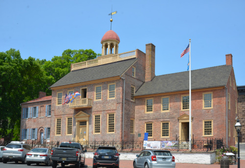
The New Castle Court House was built in 1732, 31 years after Taylor and Pierson's surveyed the Circular Line. It was not the center of the Circular Line, but it did come to play an important role in Mason and Dixon's survey.
1763-7 - Mason-Dixon
Contrary to popular belief, Mason and Dixon never had anything to do with the Arc Boundary between New Castle and Chester Counties — they had been tasked with surveying the boundary dividing Calvert’s lands (Maryland) and Penn’s lands (Pennsylvania and Delaware). This boundary included a tiny little-known circular bump due west of New Castle called the “Arc Line”. In a 1750 ruling, Lord Chancellor Hardwicke had decreed that the spire of the New Castle Court House would be the center point for this Arc Line, but that decree did not in any way apply to the Circular Line between New Castle and Chester Counties. The result of that decree was that there were now two twelve-mile circles: the 1701 Taylor-Pierson Circular Line centered on the end of the Horse Dike, and the Court House Circle centered on the spire 1600 ft further south. Later surveyors seem to have missed this distinction and conflated the two circles, usually assuming that the Court House Circle was the “correct” one.
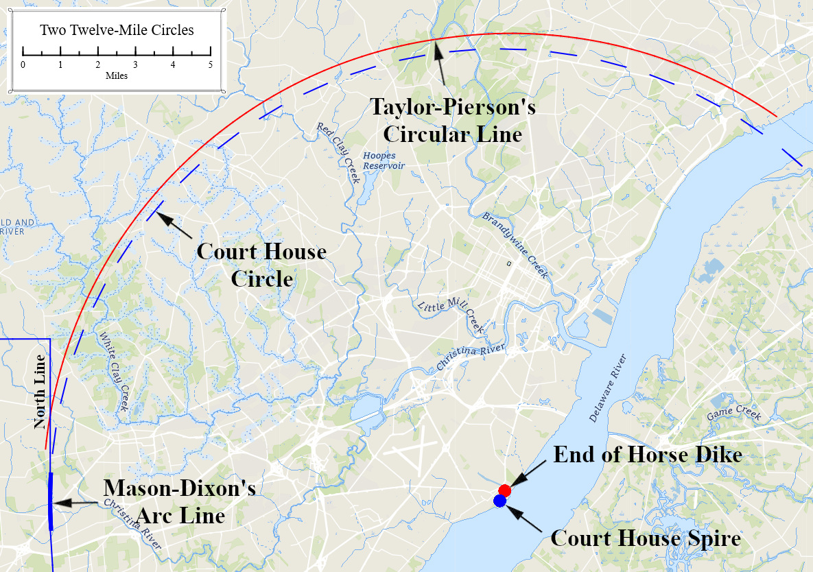
Figure 3 Two Twelve Mile Circles
The Wedge
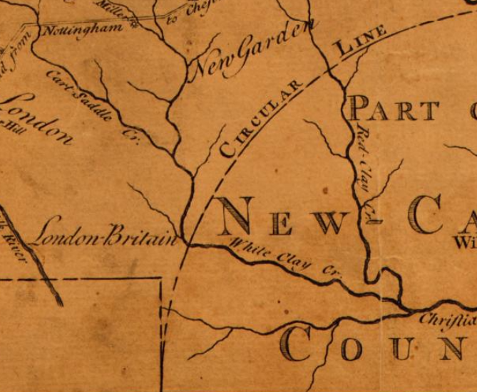
Even before Mason and Dixon had surveyed their line, cartographers realized that the parameters of the 1750 ruling would create a "Wedge" of Chester County down between the future Penn/Calvert boundary and the Circular Line. One of the earliest maps showing this Wedge was drawn by Nicholas Scull in 1759. Figure 4 Detail from the 1759 Nicholas Scull Map of Penn's Colonies 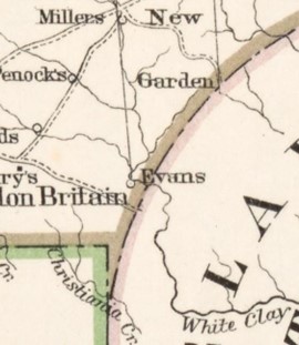
Once the Mason-Dixon Survey had been completed in 1767, a Wedge of around 310 acres situated between the North Line and the Circular Line began appearing on maps. To the left is a detail of the 1792 map of Pennsylvania by Reading Howell. Figure 5 Detail from the 1792 Reading Howell Map of Pennsylvania 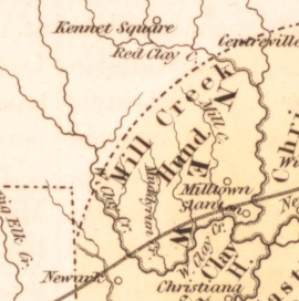
Most maps of this era showed the Wedge extending down to around the main stem of the Christina Creek. To the left is a detail of an 1838 map of Delaware. Figure 6 Detail from 1838 T. G. Bradford Map of Delaware
It appears that not many people ever saw these maps because the misconception somehow become widespread that the Circular Line actually terminated at the NE corner of Maryland. As a consequence, most residents of the Wedge came to think of themselves as Delawareans.
Not The Wedge
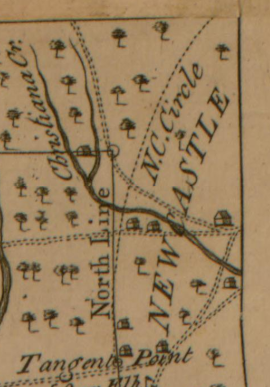
Although this map from Mason and Dixon's 1768 report looks superficially like the maps of the Wedge above, it is unlikely that Mason and Dixon intended the line marked "N.C. Circle" to show the boundary between New Castle and Chester counties. Mason and Dixon were not concerned with county boundaries, the purpose of this map was to show the new boundary between Penn's and Calvert's colonies. The many county boundaries on either side of that line were irrelevant to the effort, and none are shown on the map. Mason and Dixon had expended considerable effort in accurately locating the Tangent and Arc Lines, and the Court House Circle was the key determinate of that. The Arc Line is only barely discernible at the scale of this map (it runs from the "Tangent Point" to just below the "r" in "North Line"), so they extended the "N.C. Circle" line on the map to make it apparent. Figure 7 Detail from the
1768 Mason-Dixon Report
This seemingly innocuous extrapolation of the Arc Line on Mason and Dixon’s map may have had unintended consequences. This could very well have been the origin of the popular misconception that Mason and Dixon were the original surveyors of the Arc Boundary [12]. It also could have biased future surveyors, who would doubtless have had a deep respect for the legendary Mason and Dixon, towards thinking that the Court House Circle was the "correct" boundary line between the counties.
1849 - Graham’s Survey
|
In 1846, it was discovered that the Mason-Dixon double crownstone marker at the NE corner of Maryland [13] had gone missing, and there were also concerns that some of the other markers along the North Line may have been tampered with. As these were state boundary markers, an interstate commission was formed in 1849, and Pennsylvania, Delaware, and Maryland named commissioners. Lt. Col. James Duncan Graham [14] of the U.S. Corps of Topographical Engineers was engaged to oversee the project. In short order, he surveyed adjacent still-standing Mason-Dixon markers along the North and West lines and extrapolated back to the point where the N.E. Maryland marker should have been. There he dug straight down and discovered the base of the missing marker, and a new marker was erected on the spot. In the process, he also allayed concerns that other Mason-Dixon markers had been tampered with. |
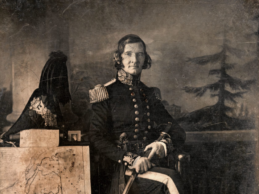
From the outset of the project, Graham and the commissioners operated under the assumption that the north end of the Arc Line was the intersection point of the three states. [15] Graham and the commissioners do not seem to have been aware of Taylor and Pierson's work [16] and assumed that the Arc Boundary was the Courthouse Circle, not the 1701 Circular Line. It is possible they were unaware of, or did not properly examine, existing maps, and they may have misinterpreted the "N.C. Circle" annotation on Mason and Dixon's map as being the state boundary.
Over the course of his fieldwork, Graham was amused to find that residents living within the Wedge considered themselves to be Delawareans and did not seem to know that they lived in Pennsylvania. So, after completing his assigned task, he took it upon himself to calculate what he considered to be the true boundary between Delaware and Pennsylvania. He proceeded to extrapolate the Arc Line north along the Court House Circle to a point 4036 feet due east of the NE corner of Maryland (approximately the location of today’s Arc Corner monument). He pronounced this the true Delaware boundary. This pronouncement had no legal effect, but it created considerable uncertainty as to the location of the actual boundary. Had it been adopted, Graham’s new line would have doubled the size of the Wedge to around 660 acres.
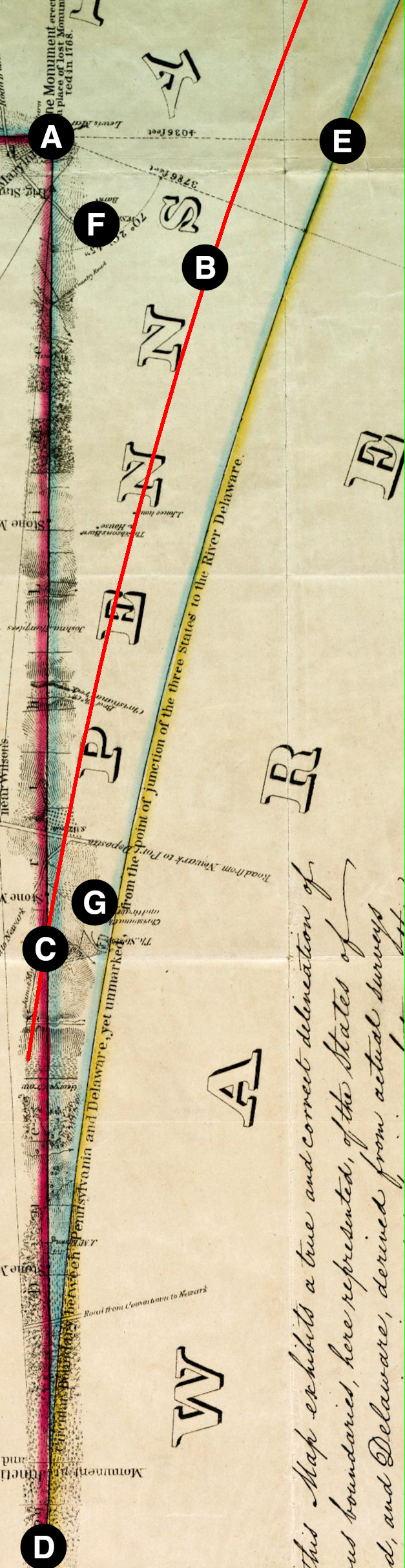
Graham's Wedge
The NE corner of Maryland.
The Taylor-Pierson Circular Line (red line added).
The intersection between the Taylor-Pierson line and the North Line. This would have been the actual intersection point between the three states at that time.
Graham's Tri-State Marker: The intersection of the north end of Mason-Dixon’s Arc Line and North Line. Graham presumed this was the intersection point between the three states and erected a new three-sided marker– each side marked with a letter “M”, “P”, or “D” depending on which state it faced. This marker is also known as the “Prism Stone”.
Graham calculated that the Court House Circle passed 4036 feet east of the NE corner of Maryland.
Graham discovered that a certain Mr. William Smith, whose home was in the Wedge (Pennsylvania), was serving in the Delaware Legislature [17]. This finding prompted considerable merriment amongst his colleagues who thereafter referred to him as “the Gentleman from Pennsylvania.” [18]
Graham erroneously determined “by careful measurement” that the good people of Christina Church were also located in Pennsylvania, however they were well within the Taylor-Pierson Circular Line. Figure 9 Graham's Wedge
1852 - Delaware Reaffirms Boundary Lines
In 1852, Delaware undertook a full revision of its statutes. The boundary‑line provisions reaffirmed the state’s long‑standing acceptance of both the Mason–Dixon Line and the 1701 Circular Line as its official borders [19]. Despite the recent concerns raised by Graham's report, no attempt was made to claim the Wedge as being within Delaware's boundaries.
1869 - Pennsylvania Act "To settle, determine and locate the southern boundary line"
In 1869, Pennsylvania authorized the formation of a boundary commission "to settle, determine and locate the line between this commonwealth and the state of Delaware, by extending the southern line of this commonwealth until it intersects the circular line of the state of Delaware". This offered a tacit surrender of the Wedge to Delaware. The act also authorized marking the Circular Line with boundary markers every quarter mile. Delaware did not respond to this offer, and maps continued to show the Wedge as belonging to Pennsylvania. [20]
1893 - Hodgkins’ Survey
By 1889 the trees that Taylor and Pierson had well-marked almost two centuries earlier were long gone and there was widespread concern that no one really knew where the Arc Boundary was anymore. By this time the Taylor-Pierson survey had been rediscovered [21], and Pennsylvania and Delaware appointed commissioners for "examining, surveying, and reestablishing" the 1701 border. William C. Hodgkins of the United States Coast and Geodetic Survey was engaged as the surveyor [22].
The Commissioners started by attempting to identify landmarks noted in the 1701 survey as well as old deeds that included the Circular Line as a boundary. They only succeeded in satisfactorily identifying three such points on the eastern half of the Circular Line and none on the western half. Hodgkins, apparently unaware of where the Horse Dike was, conflated the two circles and determined that these points were around 2000 ft beyond the “correct” Court House Circle. He unjustly blamed this discrepancy on poor surveying by Taylor and Pierson. Those three points were mathematically sufficient to define an estimation of where the Circular Line ran, but that line did not run through what the Commissioners assumed to be the “correct” point that Graham had previously determined to be 4036 feet east of the NE corner of Maryland. Hodgkins instead contrived a new arc line that connected the western-most accepted point on the Circular Line to a point near to Graham’s point [23] . This contrived arc, which had no historical basis, was calculated to have a radius of 11.58 miles. It shifted the boundary approximately 1200 feet towards New Castle at its base in the vicinity of the Arc Corner Marker. This resulted in a “Horn” of approximately 530 acres being transferred to Pennsylvania. The Commissioners also decided to go with the common understanding of the residents in the 310-acre wedge and assigned it to Delaware.
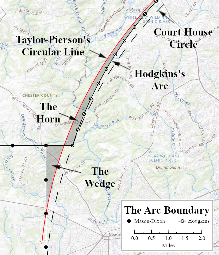
Figure 10 The Arc Boundary
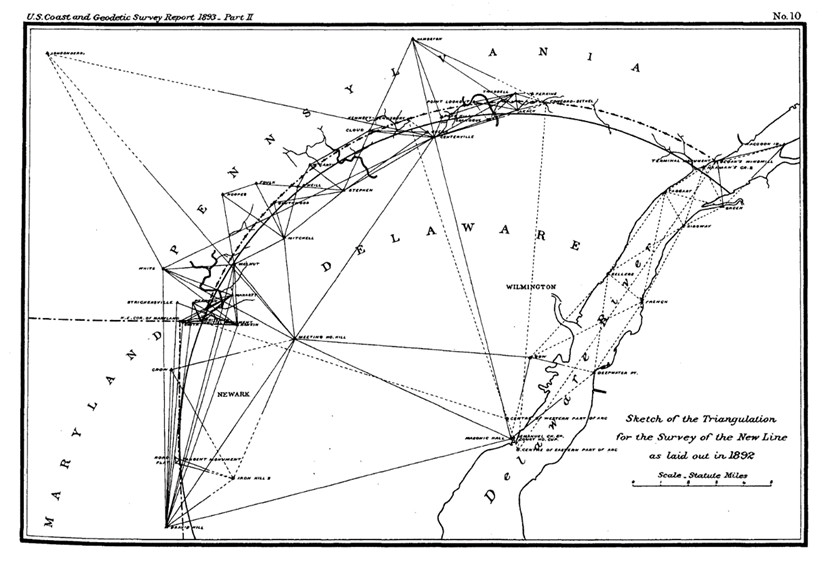
Once the Commissioners had agreed to this plan, Hodgkins and his team of surveyors commenced work. The locations for 46 markers, one every half mile along the new Arc Boundary, were precisely calculated using the geodetic formula [24]. Hodgkins then devised an elaborate triangulation scheme and erected several tall wooden towers to allow long-distance measurements to be done in the clear above tree level. Each marker was then placed at its precise location. These markers were numbered according to their distance from the Arc Corner Monument.
Figure 11 Hodgkins’ Triangulation Plan
Hodgkins’ new arc may have seemed like a good solution to the Commissioners, but it was not well received by several Delawareans who were inexplicably less than pleased to learn that their farms were now in Pennsylvania. These farmers, some of whom had lived there for generations, had a pretty good idea of where the Circular Line was, and it was definitely not along Hodgkins’ new arc. One of these farmers, John T. Johnson, accurately noted that the new arc was 1200 feet east of the original line in the vicinity of his residence [25] and proceeded to take the matter to court. In 1897 Judge Joseph Hemphill ruled [26] that the Commission had indeed exceeded its mandate to “reestablish” the old line by instead contriving a new one and struck it down. He then suggested that the new line could only be properly put into effect through ratification by the two states. Pennsylvania promptly did so, but due to the objections of the aforementioned Delawareans, Delaware did not.
Figure 12 In 1898 the USGS issued the first topographic maps for the area. In a peculiar mishmash of existing, imagined, and proposed boundaries, this map showed the entire Graham Wedge as belonging to Pennsylvania and the still unratified Hodgkins’ Arc as the boundary north of there. The locations of each of Hodgkins’ newly laid boundary stones were marked with a triangle.
1921 - Final Resolution of the Delaware-Pennsylvania Boundary
That is how things stood for several decades. Hodgkins had left behind a very well-marked boundary, erected at great expense, that was meaningless. In 1921 the Chester County Historical Society took it upon itself to revive the long-dormant issue and persuaded the Delaware Legislature, and then Congress, to adopt the Hodgkins Line. Judge Hemphill’s conditions had finally been met, and Hodgkin’s boundary line was now official.
Local farmers were again outraged. The following year, a conference of New Castle County, Delaware, and Chester County officials was convened at the Mill Creek Meeting House. Several aggrieved residents heatedly described the hardships that the boundary change had caused them. In the intervening years since Hodgkins’ survey, a few more deeds that documented the old boundary line had been discovered that had been overlooked by Hodgkins’ Commissioners. The conference determined to appoint a committee to prepare a bill for the next General Assembly to reopen the matter and re-establish the original boundary line [27]. Nothing seems to have come of that, however, and the Hodgkins Line remains the official boundary to this day.
1934 - Final Resolution of the Delaware-New Jersey Boundary
In 1934, the Supreme Court ruled in favor of Delaware over New Jersey[28] that the Taylor-Pierson Line extended across the Delaware River to the New Jersey shore despite the surveyors having ended their survey on the Delaware side. The decision was based on language in the 1682 Feoffment and Letters Patent granted by the Duke of York to William Penn which included the river, its islands, and soil within the 12-mile circle. New Jersey was unsuccessful in arguing for the customary rule that a boundary line is the main channel of navigation, however that rule did apply upstream and downstream from the 12-mile circle.
I would like to thank Sally Rickerman and Paul Lagassé for their research, insight, and suggestions.
List Of Figures
| Figure 1 | Holme, Thomas, -1695, John Harris, and Philip Lea. A mapp of ye improved part of Pensilvania in America, divided into countyes, townships, and lotts. (London: Sold by P. Lea at ye Atlas and Hercules in Cheapside, ?, 1687) Map. Library of Congress, https://www.loc.gov/item/81692881/. Overlays added by the author. ↩ |
| Figure 2 | Isaac Taylor and Taylor Pierson, The Figure of the Circular Line Dividing Between the County of New Castle & County of Chester. (1701) Map. Mason-Dixon Line papers [Am.2349 ID18096], Collection of the Historical Society of Pennsylvania. ↩ |
| Figure 3 | Two Twelve Mile Circles. Basemap: OpenStreetMaps, USGS National Map Hydro layer, Delaware Boundary Marker Locations: https://opendata.firstmap.delaware.gov/datasets/delaware::delaware-boundaries/explore?layer=0, Mason Dixon Line Stones Inventory, https://www.mdlpp.org/, retrieved 6/27/2024. ↩ |
| Figure 4 | Scull, Nicholas, 1686?-1761?, James Turner, and John Davis. To the Honourable Thomas Penn and Richard Penn, Esqrs., true & absolute proprietaries & Governours of the Province of Pennsylvania & counties of New-Castle, Kent & Sussex on Delaware this map of the improved part of the Province of Pennsylvania. Philadelphia; Sold by the author, Nicholas Scull, 1759. Map. https://www.loc.gov/item/74692506/. ↩ |
| Figure 5 | Howell, Reading, and Pennsylvania. Secretary Of The Commonwealth. A map of the State of Pennsylvania. (Harrisburg, Pa.: Secretary of the Commonwealth, 1792) Map. Library of Congress, https://www.loc.gov/item/80693000/. ↩ |
| Figure 6 | Bradford, T. G., Cartographer, Fielding Lucas, George W Boynton, and Publisher E.S. Grant & Co. Delaware. [Philadelphia: E.S. Grant and Company, 1838] Map.https://www.loc.gov/item/2017593558/. ↩ |
| Figure 7 | Mason, Charles, Jeremiah Dixon, Robert Kennedy, and James Smither. A plan of the west line or parallel of latitude, which is the boundary between the provinces of Maryland and Pensylvania: a plan of the boundary lines between the province of Maryland and the Three Lower Counties on Delaware with part of the parallel of latitude which is the boundary between the provinces of Maryland and Pennsylvania. [Philadelphia: Robert Kennedy, 1768] Map. https://www.loc.gov/item/84695758/. ↩ |
| Figure 8 | Col. James Duncan Graham, Half-plate daguerreotype by John Plumbe Jr. of Washington, D.C. National Portrait Gallery Collection. ↩ |
| Figure 9 | Lt. Col. J.D Graham, Map Showing a portion of the Boundaries of Maryland, Pennsylvania, & Delaware: as surveyed in 1849 & '50, under the direction of Lieutenant Colonel J.D.Graham, U.S. Topl. Engineers, at the request of H.G.S. Key, Joshua P. Eyre, & Geo. Read Riddle, commissioners of the respective states. (1850). Wikimedia Commons, https://upload.wikimedia.org/wikipedia/commons/c/ca/Map_of_wedge_maryland_pennsylvania_delaware_1850_survey_corps_of_engineers.png ↩ |
| Figure 10 | The Arc Boundary. Basemap: USGS National Map, Delaware Boundary Marker Locations: https://opendata.firstmap.delaware.gov/datasets/delaware::delaware-boundaries/explore?layer=0, Mason Dixon Line Stones Inventory, https://www.mdlpp.org/, retrieved 6/27/2024. ↩ |
| Figure 11 | William C. Hodgkins, “Sketch of the Triangulation for the Survey of the New Line as laid out in 1892. Part II.-Detailed Account of the Work on the Pennsylvania-Delaware Boundary Line Executed by W. C. Hodgkins, Assistant”, in Report of the Superintendent of the U. S. Coast and Geodetic Survey for the Fiscal Year Ending June 30, 1893: Part II (Washington, D.C., Government Printing Office, 1893), p. 223. ↩ |
| Figure 12 | U.S. Coast and Geodetic Survey, Topographic Sheet, Elkton Quadrangle, Maryland-Delaware-Pennsylvania, (1898). Retrieved from https://ngmdb.usgs.gov/topoview/viewer ↩ |
References
| [1] | J. Smith Futhey and Gilbert Cope, History of Chester County, Pennsylvania, with Genealogical and Biographical Sketches (Philadelphia, PA: Louis H. Everts, 1881), p. 159. ↩ |
| [2] | National Park Service, “New Castle Court House Museum”, https://www.nps.gov/places/new-castle-court-house-museum.htm. ↩ |
| [3] | Jim Meek, “Dikes in New Castle”, 2012, https://nc-chap.org/dikes/. ↩ |
| [4] | William Penn, James Logan, Deborah Logan, Edward Armstrong, Correspondence between William Penn and James Logan, Secretary of the Province of Pennsylvanis, and Others, 1700-1750: From the Original Letters in Possession of the Logan Family, vol. 1 (Philadelphia: The Historical society of Pennsylvania, 1870), p. 93. https://archive.org/details/correspondencebe01penn ↩ |
| [5] | Delaware General Assembly, An Act Ascertaining the North and West bounds of the county of New-Castle, Chapter XX, n.d., in Laws of the State of Delaware, From the Fourteenth Day of October, One Thousand Seven Hundred, to the Eighteenth Day of August One Thousand Seven Hundred and Ninety Seven, Vol. I (Wilmington, DE: Samuel and John Adams, 1797), p. 61. Retrieved from https://archivesfiles.delaware.gov/laws-of-de/vol_01.pdf. This Chapter is undated, however it is between Chapter XVIII (dated 1706 in the sidebar) and Chapter XXII (dated 1719). ↩ |
| [6] | Pennsylvania Assembly, An Act for Corroborating the Circular Line Between the Counties of Chester and Newcastle, Chapter CCV, adopted May 28, 1715, in Mitchell,James T., et al., comps, The Statutes at Large of Pennsylvania from 1682 to1801: Vol. III, 1712 to 1724 (Harrisburg, PA: Clarence M. Busch, 1896), p. 41. Retrieved from https://babel.hathitrust.org/cgi/pt?id=hvd.32044024144164&seq=11. ↩ |
| [7] | “adjacent” would have referred to areas not yet organized into townships, most likely the London Company lands to the west. New Garden had become a township in 1714. London Grove and New London didn’t became townships until 1723, and London Britian until 1725. ↩ |
| [8] | “At a Council held at Philadelpia., June the 8th, 1720”, in Minutes of the Provincial Council of Pennsylvania, 1717-1735, Vol III (Philadelphia, PA: Jo. Severns & Co., 1852), p. 91. Retrieved from https://archive.org/details/colonialrecordsov3harr/page/90. ↩ |
| [9] | Futhey & Cope, p. 42. ↩ |
| [10] | “At a Council held at Philada., May 14th, 1724”, in Minutes of the Provincial Council…, p. 236. ↩ |
| [11] | As quoted in Futhey & Cope, p 42. ↩ |
| [12] | Mason and Dixon’s journal has extensive notes and calculations concerning the lines they did survey, but there is nothing in the Journal about surveying the border between New Castle and Chester counties. ↩ |
| [13] | There were only two double crownstone markers on the Mason-Dixon line. These markers had Calvert's shield on the south and west sides and Penn's shield on the north and east sides. The remaining one can still be seen down at the SW corner of Delaware. ↩ |
| [14] | https://en.wikipedia.org/wiki/James_Duncan_Graham ↩ |
| [15] | Lt. Col. James D. Graham, Reports of the Joint Commissioners and of Lieut. Col. Graham, U.S. Engineers, in Relation to the Intersection of the Boundary Lines of the States of Maryland, Pennsylvania, and Delaware (Washington, D.C.: Gideon and Co., 1850). Retrieved from Library of Congress: https://tile.loc.gov/storage-services/public/gdcmassbookdig/messagefromgover01comm/messagefromgover01comm.pdf, Letter from Commissioners to Graham dated Nov. 12, 1849, p. 10. ↩ |
| [16] | There is no mention of the 1701 Taylor-Pierson survey in Graham’s Report. His report documents several trips to the archives at Annapolis to study the Mason-Dixon papers, but none to Philadelphia to examine the Taylor-Pierson documents (these documents are currently held at the Historical Society of Pennsylvania, founded 1824, but it is unclear if they were in the collections in 1849). ↩ |
| [17] | William Smith served in the Delaware House from 1847-49 and in the Senate from 1853-55, https://en.wikipedia.org/wiki/List_of_Delaware_General_Assembly_sessions. ↩ |
| [18] | John T. Faris, The Romance of the Boundaries (New York: Harper & Brothers, 1926), p. 232. ↩ |
| [19] | Delaware Legislature, Of Sovereignty, Jurisdiction and Limits, Chapter 1, Sec. 2, adopted 1852, in Revised Statutes of Delaware: An Act For Revising, Arranging and Amending the Public Laws of the State of Eighteen Hundred and Fifty-Two (Wilmington, DE: Mercantile Printing Co., 1893), p.3. Retrieved from https://www.google.com/books/edition/Revised_Statutes_of_the_State_of_Delawar/1uAXAAAAYAAJ. ↩ |
| [20] | Pennsylvania General Assembly, To settle, determine and locate the southern boundary line of this Commonwealth, in Laws of the General Assembly of the State of Pennsylvania passed at the Session of 1869 (Harrisburg: B. Singerly, State Printer. 1869), p. 13. retrieved from: https://archive.org/details/lawsofgeneralas_1869penn/page/12/mode/2up. ↩ |
| [21] | Following the Centennial celebration in 1876, people began to realize that this was not a new country anymore and that there was some history to celebrate. All across the country, massive local histories were compiled by now-legendary historians. The History of Chester County was published by John Futhey and Gilbert Cope in 1881, and the History of Delaware County, Pennsylvania by Henry Ashmead followed in 1884. Both had detailed accounts of the Taylor-Pierson survey as part of their descriptions of their respective county boundaries. So unlike Graham in 1849, Hodgkins would have quickly learned of the Taylor-Pierson survey when he took up his assignment in 1889. ↩ |
| [22] | Hodgkins, “Part II.-Detailed Account of the Work on the Pennsylvania-Delaware Boundary Line Executed by W. C. Hodgkins, Assistant”, in Report of the Superintendent…, pp. 202-215. ↩ |
| [23] | Hodgkins correctly noted that Graham's distances were off and placed his Arc Corner Mounument about 130 feet east of the point Graham had calculated. ↩ |
| [24] | The geodetic formula models the earth as an ellipsoid (a slightly flattened sphere), and the equations are more daunting than the usual planar trigonometric ones that most of us struggled with in high school. The fact that the earth is an ellipsoid had been known since the early eighteenth century, and by 1893 scientists in different countries around the world had made various calculations for the degree of ellipticity. The one used by the United States Coast and Geodetic Survey was developed by an Englishman, Col Alexander Ross Clarke (1828–1914). Clarke’s 1866 estimate of the radius of the earth at the equator differs from the value used today by only about 200 ft. ↩ |
| [25] | “The State Boundary Line … A Victory for John T. Johnson”, Delaware Gazette and State Journal (Wilmington, DE), February 18, 1897, p. 1. Johnson’s residence was located in what is now the south-east corner of London Britain Township. ↩ |
| [26] | The Honorable Joseph Hemphill, "New Castle Circle Boundary Case. Johnston v. Crossan." Judicial Districts of the State of Pennsylvania during the year 1897. Vol. VI. (Philadelphia: Eward P. Allison, 1897), pp. 184-191. ↩ |
| [27] | “Would Substitute Old Boundary for the Present Line”, Wilmington Morning News (Wilmington, DE), June 8, 1922, pp. 1, 5. ↩ |
| [28] | New Jersey v. Delaware, 1934. 291 U.S. 361. retrieved from https://supreme.justia.com/cases/federal/us/291/361/ ↩ |