Rediscovering the Taylor-Pierson Circular Line
David R. Hawk
The Circular Line dividing New Castle and Chester Counties was surveyed by Isaac Taylor and Thomas Pierson in 1701. The line was not marked with permanent boundary stones, but only with notches cut into trees. Over the ensuing decades, the notches healed over, the trees disappeared, and eventually there was some confusion as to exactly where the line ran. This study aims to rediscover the original path of the Circular Line that Taylor and Pierson laid out 325 years ago.
To reconstruct the original route, this study will first review the plan employed by Taylor and Pierson for their survey. Next, it will analyze the practical limitations of the period’s surveying technology and assess how these may have led to deviations from the intended plan. A model "Red Line", adhering to the original plan but incorporating slight variations attributable to the limitations of their surveying technologies, will be introduced. This Red Line will be assessed against present-day parcel boundaries, evidence accepted by the Hodgkins's commissioners in 1893, and folk memory of where the original line was believed to run.
|
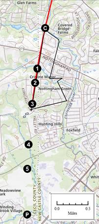
Figure 1 Evidence of the original Circular Line |
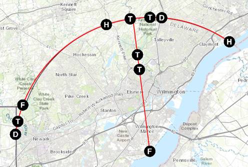
The above map shows where evidence of the original Circular Line has been found.
 – Deed and
Patent Evidence
– Deed and
Patent Evidence
 – Folk Memory
Evidence
– Folk Memory
Evidence
 – Evidence
accepted by the Hodgkins Commission.
– Evidence
accepted by the Hodgkins Commission.
 – Evidence
from the Taylor-Pierson Survey Map
– Evidence
from the Taylor-Pierson Survey Map
William Penn’s Warrant
In 1701, William Penn issued a warrent ordering the survey:
Admeasure & Survey from ye Town of New Castle the Distance of twelve Miles on a Right Line by ye River Dellaware Upwards & from the sd Distance to Divide Between the sd Counties By a Circular Line … ye sd Circular Line to be well marked two third parts of ye SemiCircle [1]
A “right line” is simply a straight line, and “two thirds parts of ye SemiCircle” is a convoluted way of saying 120°.
The Plan of the Survey
|
Figure 2 The Isosceles Triangle |
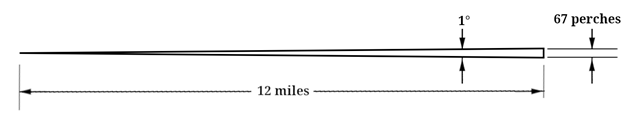
Taylor and Pierson used a simple isosceles triangle as the basis for their survey. They calculated that for a triangle with two twelve-mile-long sides and a 1° base angle, the third side would have a length of sixty-seven perches (1105.5 ft).
|
Figure 3 An Approximation of the Circular Line |
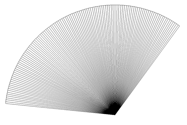
The vertices of 120 such triangles would create a reasonable approximation of the requested “two-thirds of a semicircle”.
The survey would be conducted by measuring a 12-mile radial line out from New Castle (any radial line would have done, but they chose a “Due North” line), and then, proceeding eastwards, marking off the vertices of as many isosceles triangles as was necessary to reach the Delaware River. Then, returning to the end of the Due North Line, repeating the process westwards, marking off the vertices of as many triangles as were needed to mark 120 triangles in total, thereby surveying the requested two-thirds of a semicircle.
The beauty of this scheme was the simplicity of surveying successive triangles. There was no need to return to New Castle and measure out a new 12-mile radius for each triangle. Instead, starting at the last vertex of the previous triangle, a new sixty-seven perch chord was measured at a bearing 1° to the south of the previous chord’s bearing (90°, 91°, 92°, etc.). The end of each chord marked the vertex of a new isosceles triangle, and, in theory, each such vertex should have been twelve miles from New Castle.
This scheme was susceptible to measurement errors, however.
Chaining Errors
|
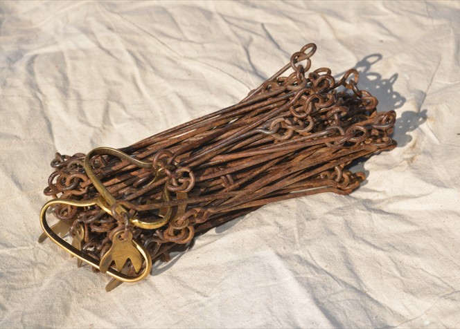
Figure 4 Surveying Chain |
Distances in those days were measured using a Gunter's Chain. These chains were sixty-six feet long and were stretched out over the ground to be measured. Surveyors needed to be careful to keep the chain level to ensure the distances were measured accurately. This was difficult to do over the hilly terrain covered by this survey. The chains were also susceptible to stretching and needed to be pounded back to the correct length every now and then. |
|
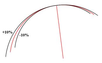
Figure 5 Potential Deviations Due To Chaining Errors |
If the surveyors were a bit long on their chaining measurements, the arc would flare outwards from the desired circle. Likewise, if the chaining was short, then the arc would shrink inwards. The illustration to the left shows the effect of consistent plus or minus 10% chaining errors over the course of the survey. This study will show that Taylor and Pierson ran about 1% long on their chaining. |
Compass Errors
|
The survey plan was highly dependent on compass measurements with 120 chords, each at a different angle, to be measured. Given that most of the survey was through forests, multiple measurements could have been needed for each chord.
The outer ring of the compass face to the left is divided into 360 degrees, each degree a tiny division of the circle. Although not shown on the compass face because it is too small, each degree is further subdivided into 60 minutes. An accomplished surveyor with a good compass could measure a bearing to a half or perhaps even a quarter of a degree (30 or 15 minutes). |
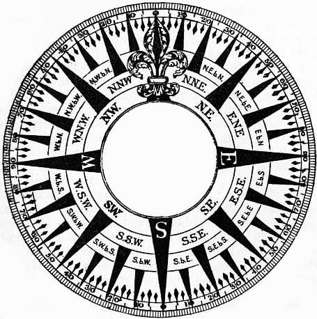
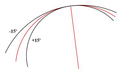
Figure 7 Potential Deviations due to Systematic Compass Errors |
If the surveyors systematically undermeasured the bearing on each chord change, the effect would be to widen the circle. Similarly, if each bearing were systematically over-measured, the circle would be pulled inwards. The illustration to the left shows the effect if each chord measurement were systematically 15 minutes (¼°) off either way. As can be seen, any systematic compass errors would have had a major impact on the survey. |
Even skilled surveyors were unlikely to consistently achieve compass measurements with less than ¼° errors. Fortunately, however, measurement errors tend to average out with errors in one direction being cancelled by other errors in the opposite direction. That appears to have been the case with Taylor and Pierson’s measurements. This study will show that the average error, over hundreds, or perhaps thousands of measurements, was less than a couple of minutes.
Starting point at New Castle
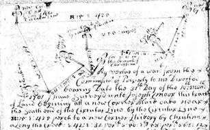
From the Taylor-Pierson Survey Report[2]:
These are to Certifie that on ye twenty fifth day of ye Ninth Month 1701 Wee met at New Castle with Cornelius Empson Richard Halliwell & John Richardson Justices of ye County of New Castle & Caleb Pusey Philip Roman & Robert Pile Justices of the County of Chester who Did Unanimously Conclude that the Beginning should be at the End of the Horse Dike next ye sd Town of New Castle…
This leaves unclear which end of the 1143 ft long[3] Horse Dike they started from. The best answer seems to come from a newspaper account written in 1922 by William A. Kimmey, a civil engineer:
In 1875 I took up from the side of the road a stone peculiarly marked and placed it as a centre stone for Fourth street and the Wilmington road. This stone I was told by several very old men was regarded by them and their fathers as being the centre of the twelve mile circle and that I should not have removed it. This stone is about twenty-five feet from where I took it and can be easily replaced in its original position.[4]
That intersection is at the south end of the Horse Dike, and the coordinates of the center of the intersection are approximately 39°39′49.3″N, 75°33′38.9″W[5]. Kimmey does not say in which direction the stone was removed twenty-five feet from, so the center of the intersection is used as the starting point for the Red Line in this study.
|
Figure 8 The Starting Point for the Taylor-Pierson Survey |
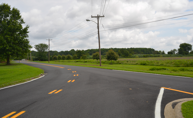
The above photo looks north across the intersection of Fourth St. and Wilmington Rd in New Castle where the Taylor-Pierson survey began. The Horse Dike (a.k.a Broad Dyke, now Wilmington Rd) was built in 1675 to carry horse carts across the marsh at the north end of town. To the left in the distance can be seen the bridge that crosses over the Broad Dyke Channel that runs down the middle of the marsh.
The Due North Line
…the twenty sixth day of ye sd Month we Did begin in ye Presence of ye sd Justices at the sd End of ye Horse Dike and Measured Due North twelve Miles to a White Oak Marked with twelve Notches standing on ye West side of Brandy Wine Creek in the Land of Israel Helm…
Taylor-Pierson Survey Report
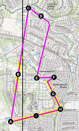
|
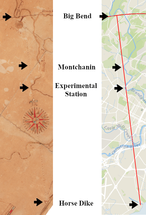
Their survey map contains several clues as to the path they took for their “Due North” line.” Their route is marked with a faint dotted line that starts at the Horse Dike at New Castle (marked with an “A”), proceeds through the center of the compass rose, and terminates at the “White Oak” near the top[6]. Their route crossed the Christina River, and then crossed the Brandywine twice just on the inside edge of a small bend below today’s Experimental Station. Their map does not indicate they got anywhere near the bluffs east of Montchanin, even though modern maps show they could not have been too far away. Their twelve miles ended at a White Oak just east of Big Bend. |
| Figure 9 Points of interest along the North Line |
Finding the Bearing of the Due North Line
Since Penn’s surveyors did not correct for magnetic declination, their land surveys appear tilted slightly to the west when viewed on modern maps. Following their standard practice, Taylor and Pierson’s “Due North” line ran magnetic north rather than true north.
Two clues on the survey map narrow down the actual path they took to a slim range.
 |
 |
|
|
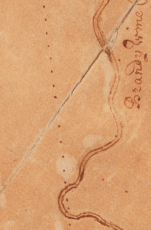
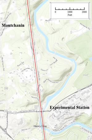
Figure 10 Two points along the Brandywine, Taylor-Pierson detail |
Figure 11 Two points along the Brandywine, modern map. |
The survey map shows their path crossing and re-crossing a bend of the Brandywine in the vicinity of the Experimental Station. The dotted line indicates that they crossed up onto dry land between crossings. The leftmost grey line on the modern map just touches the riverbank and indicates the westernmost possible path – any further west, and they would not have crossed up onto dry land. This grey line has a bearing of 7°33′W.
Further north, as can be seen on the modern map, the survey line passed near the top of a 100 foot high bluff overlooking the Brandywine about a third of a mile east of Montchanin. Interestingly, the Taylor–Pierson survey shows their line passing nowhere near the river, suggesting that the bluff seemed to them to lie well off their path (at least as they remembered it when they drew their map afterwards). The rightmost grey line, drawn right at the edge of the bluff, is at a bearing of 7.09°W. Had the survey gone further east, the survey path would have have dropped down over the edge of the bluff, and Taylor and Pierson would have remembered that when they drew their map and would have sketched the river closer to the survey path than they did.
Splitting the difference between the two grey lines, the model Red Line uses a bearing of 7.21°W for the Due North Line. This would document the magnetic declination in this vicinity in 1701.
Finding the extent of the twelve-mile Due North Line
|
|
|
|
|
Figure 12 Due North Line terminus at the White Oak, Taylor-Pierson detail. (note the “Indian Town”) |
Figure 13 Due North Line terminus, modern map. |
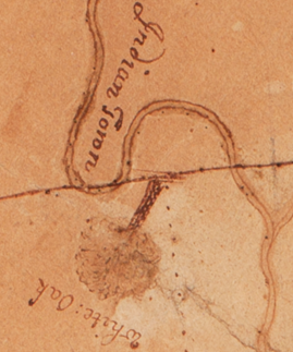
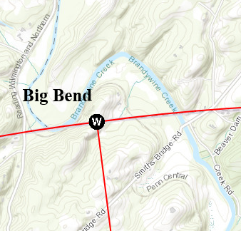
In the above survey map detail, it can be seen that the Circular Line
touches the northern shore of the Brandywine at Big Bend. That, and
the previously established bearing for the Due North line, establishes the
position of the White Oak  for the model Red Line as approximately 39°50′17.0″N, 75°35′22.7″W.
The distance from the Horse Dike to the White Oak was 12.127 miles rather than the twelve miles they aimed for. This represents a chaining overrun of 672 ft, or 1.06%. This is not surprising given the difficulties in using a surveying chain on hilly terrain.
The Eastern Arc
from the sd White Oak Wee Ran Eastward Circularly changing our Course from the East Southward one Degree at the End of Every Sixty Seven Perches which is the Chord of one Degree to a twelve Miles Radius & at ye End of forty three Chords wee Came to Delaware River on ye upper Side of Nathaniel Lamply’s Old Hous at Chichester
Taylor-Pierson Survey Report
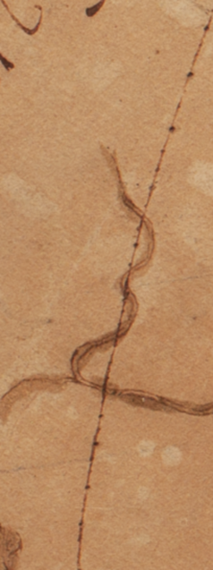
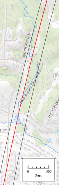
Beaver Creek
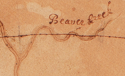
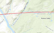
Heading east, after crossing the Brandywine, Taylor and Pierson crossed and re-crossed Beaver Creek. The creek meanders over a 500 ft wide range in this vicinity, and as can be seen the Red Line also crosses and re-crosses the creek.
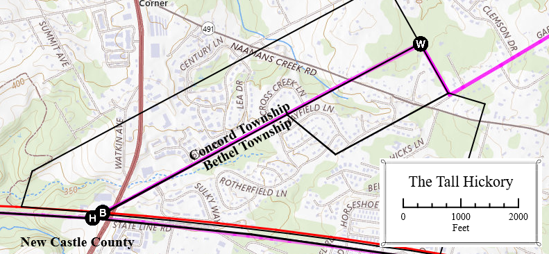
Concord-Bethel, The Tall Hickory Tree
Hodgkins, in his 1892 report, used three points to determine the eastern Arc Boundary line. This is his description of how a point along the boundary between Concord and Bethel townships was selected:
Mr. Benjamin H. Smith, of Philadelphia, was the "surveyor for Pennsylvania," and Mr. Daniel Farra, of Wilmington, was the "surveyor for Delaware." These gentlemen appear to have examined with considerable care the available documents, county records, etc., which might throw light upon the question.
Starting from the Delaware River and going westward, they seem to have been mutually satisfied that they had identified with reasonable certainty, as parts of the line of 1701, the following marks: …the boundaries of some farms west of the, "Concord Turnpike" and east of Brandywine Creek, the original patents for which lands called for the circular line as their southern boundary;[7]
… on May 18, I accompanied Messrs. Smith and Farra on a visit to the portion of the old line in the vicinity of Brandywine Creek, where some traces of the former work are still to be identified. I was shown … A tall hickory tree standing on the supposed old line at the corner common to the townships of Concord and Bethel, Delaware County, Pa., was selected by the surveyors as the reference point for that part of the line.[8]
Hodgkins gives coordinates for this tall hickory tree as the
“Concord-Bethel” point in his report. That location is marked as on the map
below:
|
Figure 16 Hodgkins's
Concord-Bethel Point. |
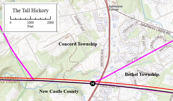
This point is slightly over 100 ft south of the Red Line model proposed by the study. That is a large enough discrepancy to warrant further examination, and several historic deeds were checked in order to investigate this. To be useful, such deeds had to:
- Include the Circular Line as one of its boundaries.
- Predate Hodgkins’s work to ensure it was the surveyor’s understanding of the original Circular Line.
- Have at least one other point that can be accurately located on a modern map, such as a road or a township boundary.
- Original patent surveys were not used since the accuracy of the bounds is suspect. Original patents typically included a 6% allowance for roads, and often this was accomplished by inflating chain measurements so that the resulting tract was bigger than the reported area. Penn also had problems with surveyors accepting payments from landowners to lay out larger tracts than were specified by the warrant. Subsequent surveys, which were recorded in deeds rather than patents, tended to be more accurate since it was in the seller’s interest not to under-report the acreage being sold.
Several such deeds were found in the vicinity of the Concord-Bethel point that were useful.
1775 William Burnett Tract
|
Figure 17 1775 William Burnett Tract |
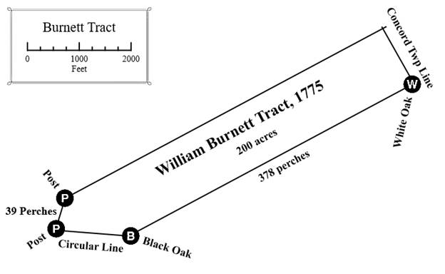
In 1775 Joseph Guest sold a two hundred acre tract “in the Manor or Reputed Manor of Rocklands in Concord Township” to William Burnett[9]. The boundary description is of interest in that one leg of it is on the Circular Line and another leg is on the Concord Township line. The distance between a Black Oak on the Circular Line and a White Oak on the township boundary was measured to be 378 perches[10]. As will be discussed later, the western boundary of this tract was marked by two posts thirty-nine perches apart.
|
|
The description of the location in this deed was a bit dated by 1775, but a little history will help explain it and locate this tract. The 1695 Holme map to the left was made before the Circular Line was surveyed. It shows Concord Township as square-shaped and marked with a yellowish-brown border. The reddish-brown line was the New Castle County border at the time. The Manor of Rockland, most of which was located in today’s Delaware, is to the west and south of Concord Township. The portion of Rockland Manor containing the future Burnett tract was reassigned to Chester County after the Circular Line was drawn in 1701. |
|
|
Figure 18 1685 Thomas Holme Map |
|
|
After the Circular Line was drawn in 1701, several tracts from Rockland Manor were added to Concord Township thereby altering its original square shape. One of these tracts was the Burnett tract. |
|
|
Figure 19 Concord Township in 1848 |
|
Figure 20 The Burnett Tract in 1848 |
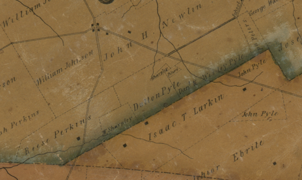
The lines of the Burnett tract, although it has been subdivided into several smaller tracts, can still be seen in this detail of Concord Township in 1848. It extends from “Reese Perkins” to “Ph Peters” at the corner (just above “John Pyle”). The southern edge of the Burnett tract is the township boundary, and its length should be 378 perches according to the 1775 survey.
|
Figure 21 Southern boundary of the Burnett Tract |
Modern GIS data provides coordinates for the corner of the
township boundary where the White Oak once stood . The distance
from there to the proposed Red Line along the boundary is 377.1 perches,
within 15 ft of the 378 perches measured to the Black Oak  on the
Circular Line in the 1700s. The location of the Tall Hickory that Hodgkins’s team selected for the
Concord-Bethel point is an additional 220 ft to the southwest along that
same line. Allowing for the angle, this makes Hodgkins’s boundary
line in this vicinity to be around 100 feet south of where the Circular Line
was in the 1700s.
on the
Circular Line in the 1700s. The location of the Tall Hickory that Hodgkins’s team selected for the
Concord-Bethel point is an additional 220 ft to the southwest along that
same line. Allowing for the angle, this makes Hodgkins’s boundary
line in this vicinity to be around 100 feet south of where the Circular Line
was in the 1700s.
An examination of the adjoining 1702 Nathaniel Newlin Tract reveals a similar 100 foot discrepency.
1702 Nathaniel Newlin Tract
|
Figure 22 1702 Nathaniel Newlin
Tract |
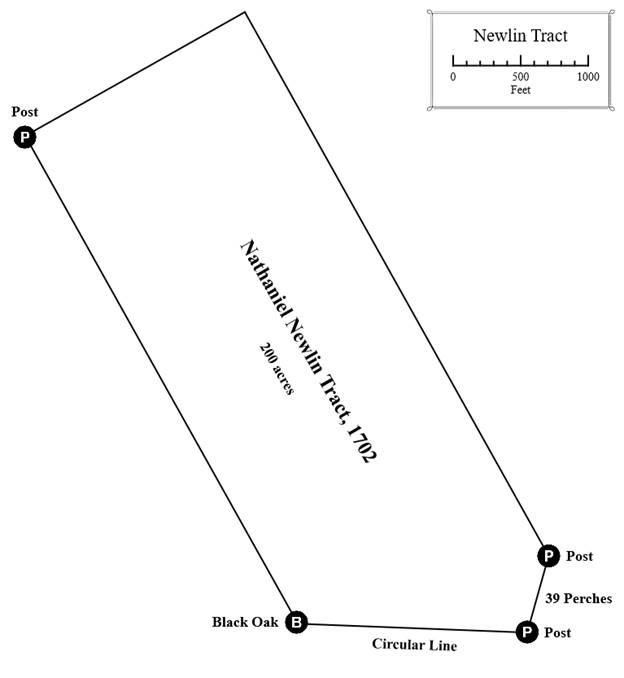
In 1702, Nathaniel Newlin patented a two-hundred-acre tract on the Circular Line[11]. Note that the southeastern corner of this tract is marked by the same two posts, thirty-nine perches apart, that marked the southwestern corner of the Burnett tract. Note also the Black Oak and the Post marking the corners on the western side of this tract. Being a patent survey, the measurements are understated, in this case by approximately 3% to provide the allowance for the roads, so surveys from later subdivisions of this tract will be used for more accurate measurements:
|
Figure 23 1750 Robert Green Tract |
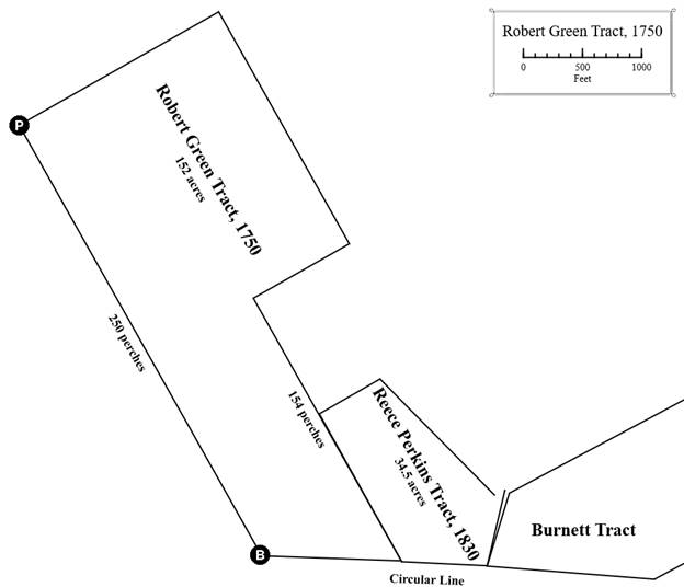
In 1750, Robert Green purchased 152 acres of the old Newlin Tract[12]. The survey used the same Black Oak and Post along the western boundary that marked the 1702 survey. The 1830 Reece Perkins Tract[13] is also shown to establish the position of the Green Tract relative to the previously discussed Burnett Tract. Two legs of the Green Tract are of interest, one 250 perches long[14], and the other 154 perches long[15].
|
Figure 24 1750 Robert Green Tract on modern map |
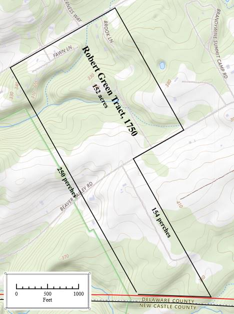
When overlaid on a modern map, it can be seen that two of the Robert Green Tract boundaries were along Smith Bridge Rd and Beaver Valley Rd. The distance from these roads to the Circular Line was 250 perches and 154 perches, respectively. The calculated Red Line falls quite close to the southern end of those lines; however, the boundary Hodgkins drew in 1892 is about 100 ft further south.
From these three colonial measurements, it would seem that Hodgkins erred in 1892 in accepting Messrs. Smith and Farra’s tall hickory tree as being on the original Circular Line. This had unrecognized consequences for Hodgkins’s survey, as it threw off his entire triangulation scheme for his Eastern Arc, which relied on this point and two others to determine the radius of the arc[16].
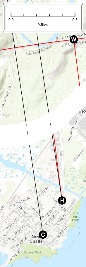
The old Hous of Nathan Lamply
The eastern end of Taylor-Pierson’s survey was at Nathan Lamply’s old house (old in 1701!) on the edge of the river. It was marked “B” on their survey map. In 1892, Hodgkins located the ruins of the house and provided coordinates.
|
|
|
|
|
Figure 25 Terminus of Eastern Arc, Taylor-Pierson detail |
Figure 26 Terminus of Eastern Arc, modern map |
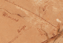
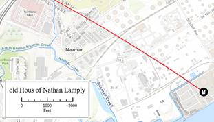
Today this spot is located within the Marcus Hook industrial complex and is now about 500 ft inland from the edge of the river.
An exact distance measurement to the riverbank was unnecessary for the purposes of Taylor and Pierson’s survey, and they do not provide one other than it is at/beyond the “end” of the forty-third chord.
The Western Arc
then wee Returned to the sd White Oak in Israel Helms Land & from thence we Ran Westward Changing our Course one Degree from the West Southward at ye end of Every Sixty Seven Perches as before untill we had Extended Seventy Seven Chords
Taylor-Pierson Survey Report
Kennett-Pennsbury
Hodgkins and his surveyors identified this point as being on the original Taylor-Pierson line and Hodgkins used it as one of the three defining points for his Eastern Arc.
... I was shown the old hickory stump at the southeast corner of Kennett township…[17]
… a large hickory stump, which marks the point at which the line between the townships of Kennett and Pennsbury, in Chester County, strikes the circular line of 1701. This last point is a particularly notable one. The old tree, which was standing a few years ago, was no doubt in existence in the time of William Penn. It is mentioned as a "small hickory" in a deed[18] given in 1713 by George Harlan to his son, James Harlan, for two hundred acres of land, a part of the "manor of Staneing," granted by patent by William Penn to his daughter Letitia in 1701. The hickory was described as being "in ye eastern line of ye said manor.''[19]
John T. Johnson
He does not say how he determined this, but in 1897, John T. Johnson complained that Hodgkins’s proposed new boundary was 1200 feet from the Circular Line.[20] This bit of folk memory seems accurate, as the calculated Red Line is 1230 feet from the Arc-Corner Monument and around 1170 feet in the vicinity of his farm.
The East Branch of the Christina
Taylor-Pierson’s survey map shows the Circular Line crossing and re-crossing the Eastern Branch of the Christian River as it descends south to join the main stem.
|
|
|
|
|
Figure 27 East Branch of the Christina, Taylor-Pierson Detail |
Figure 28 East Branch of the Christina, modern map |
|
|
The Taylor-Pierson survey map shows the Circular Line crossing and recrossing the East Branch of the Christina River. |
A modern topographic map shows the range of the meandering (bracketed by the black lines) to be approximately 350 ft in this area. |
1702 Joseph Moor Survey
|
|
In 1702, the year after the Taylor-Pierson survey was completed, a 255-acre tract was surveyed for Joseph Moor. This survey started “near the South end of the Circular Line” and proceeded northwards along the Circular Line for 425 perches (slightly over 1¼ mile) to the Christina Creek. This was surveyed as a straight line and did not attempt to conform to the curve of the Circular Line. |
|
| |
Figure 29 1702 Joseph Moor Survey |
The Moor survey is shown below plotted on a modern map.
|
|
 :
“Beginning ... near the South end of the Circular Line.”
:
“Beginning ... near the South end of the Circular Line.” :
“white oak standing in a branch of Christina.” This branch
is not shown on the topographic map; however, its path is
indicated by the two ponds to the west of it.
:
“white oak standing in a branch of Christina.” This branch
is not shown on the topographic map; however, its path is
indicated by the two ponds to the west of it. :
along land of John Ogle. This section of the original
tract boundary survives in today’s parcel boundaries.
:
along land of John Ogle. This section of the original
tract boundary survives in today’s parcel boundaries. :
This section of the original tract boundary also survives in
today’s parcel boundaries.
:
This section of the original tract boundary also survives in
today’s parcel boundaries.This was a patent survey, and as previously mentioned, patent survey measurements are usually understated. To reach all of the known points mentioned in the survey, all plotted survey lines had to be inflated by 9%, and the resulting tract was actually 275 acres, or 7% more than the 255 acres that the warrant called for. This overage was probably intended as the standard 6% allowance for future roads across the property.
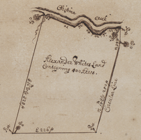
1704 Alexander White Survey
|
|
In 1704, surveyor Thomas Pierson laid out a tract for Alexander White on the West side of the Circular Line adjoining Joseph Moore’s tract. |
|
|
Figure 31 1704 Alexander White Survey |
This survey is shown below plotted on a modern map.
|
|
The survey lines for this tract were also inflated by 9%, yielding a 473 acre tract rather than the four hundred acres called for in the warrant. This 18% overage was quite a bit above the standard 6%.
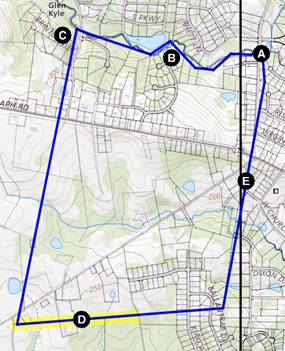
Plotting all the relevant lines on a modern map:
|
The map to the left shows the calculated Red Line, the 1702 Joseph Moor Survey (purple), and Pierson’s 1704 survey for Alexander White (Blue). Both Moor’s and White’s lines in this vicinity were surveyed from south to north, ostensibly along the Circular Line, but each chose a different bearing to approximate the Circular Line. Pierson’s line seems slightly more accurate, about 40 ft off near the top.
|
| Figure 33 Convergence Point near the South end of the Circular Line |
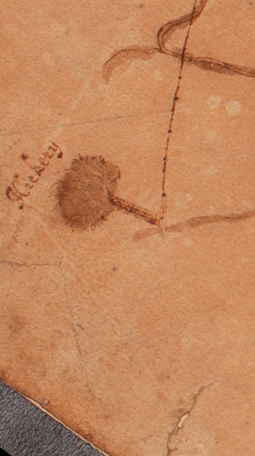
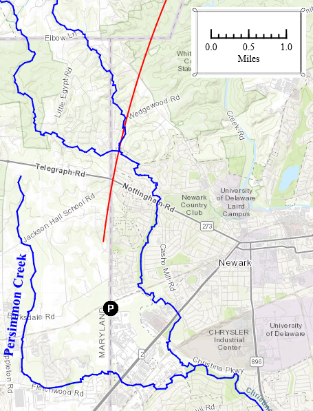
Western Terminus - the Hickery Tree
…to a Marked Hickery Standing Neare ye Western Branch of Christina Creek Surveyed the 4th day of the 10th month 1701…
Taylor-Pierson Survey Report
This "Western Branch of Christina Creek" is unlikely to be what is known today as the West Branch of the Christina River. Prior to the twentieth century, the West Branch of the Christina River was known as “Persimmon Creek” (1849)[21] or “Persimmon Run” (1881)[22]. Taylor-Pierson would have had to have overshot their “two-thirds of a semicircle” by 1¾ miles, or eight degrees (85 chords rather than 77) to have reached Persimmon Creek. Each excess chord would have required an extra 1° compass change, and this would not have gone unnoticed by the surveyors.
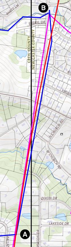
Instead, the “Western Branch” was likely one of several small streams that flowed into the Christina from the west. Below is the elevation profile derived from LIDAR data[23] along the western end of the Circular Line between the East Branch of the Christina River and extended down to Persimmon Creek[24]. Low points along the line indicate the location of five small streams.
|
Figure 34 Elevation Profile along the Circular Line |
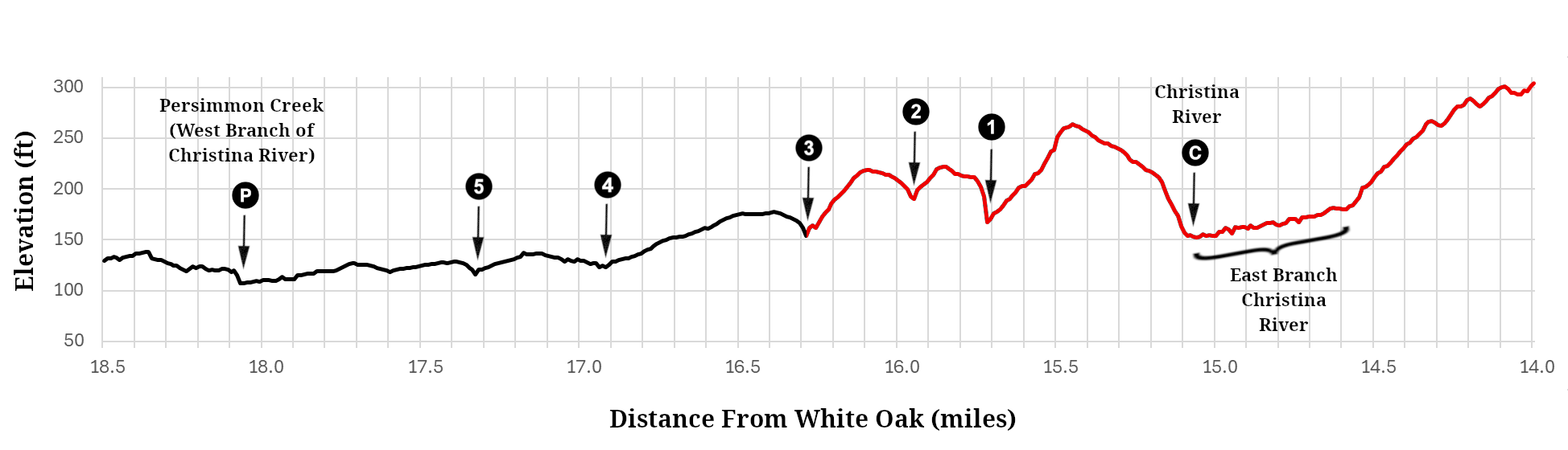
Starting on the right side of the profile, the Circular Line drops down
to the East Branch (14.6 miles from the White Oak) and crisscrosses it
until it intersects with the Main Branch  (at 15.06 miles). Then it climbs and dips down
across two small streams at 15.72 (marked
(at 15.06 miles). Then it climbs and dips down
across two small streams at 15.72 (marked  ) and 15.95 (marked
  ) miles. The Hickery was most likely
alongside stream
) miles. The Hickery was most likely
alongside stream  at 16.29 miles. This stream is known today as Briar Creek.
Going further south, the line crosses two more streams (
at 16.29 miles. This stream is known today as Briar Creek.
Going further south, the line crosses two more streams ( at 16.94 and
  at 17.33 miles) before finally reaching
Persimmon Creek
at 17.33 miles) before finally reaching
Persimmon Creek  (now known as the West Branch of the Christina) at 18.06 miles.
These locations appear on the following maps (all scaled approximately the same):
|
|
|
|
||
|
Figure 35 Hickery at the Terminus of Western Arc |
Figure 36 Terminus of Western Arc on 1898 Topographic Map |
Figure 37 Terminus on modern map |
||
|
The scale on the Taylor-Pierson survey plat indicates that the
Hickery was approximately 1⅓ miles south of Christina
Creek. The distance along the calculated Red Line from the
Christina to Briar Creek (stream |
Unlike modern topo maps, the 1898 USGS Topographic Map shows all five streams south of the Christina River. |
Today’s topographic maps do not show stream |
||
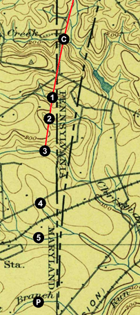
Thus, all available evidence points to what is now known as Briar Creek
(stream ) as
being the location of the Hickery at the end of the Circular Line.
The GIS coordinates for the location of the Hickery is approximately 39°40′59.8″N 75°47′25.5″W.
Parameters for the Red Line Model
Delaware Boundary Markers
This study uses the "authoritative" coordinates for the monuments marking Delaware's boundary from Delaware's FirstMap webpage.[25]
Hodgkins Coordinate Adjustments
This study uses some coordinates measured or calculated by Hodgkins in 1892 that are not available from FirstMap. Hodgkins did his work by triangulating from a grid of benchmarks that government surveyors had already established in the region. That regional grid, which predates both NAD27 and NAD83, needed to be adjusted to be compatible with today’s coordinates. Many of the Hodgkins monuments have been accurately located using GPS,[26] and by comparing Hodgkins’s coordinates with FirstMap coordinates, it was found that Hodgkins’s coordinates needed to be adjusted 83 ft at a bearing of 93.5°E. Once this was done, the largest error noted was less than 11 ft.
Coordinates for Nathan Lamply's House
Hodgkins survey found that the ruins of Lamply's house were 49.6 feet and at a bearing of 123°24′E from where he placed his Terminal Marker. For the purposes of this study, the coordinates of the ruins were determined to be at that distance and bearing from the location FirstMap gives for the Terminal Marker.
Local Compass Variations
The magnetic declination at a given location changes over time. A direction indicated by a compass in 1701 will be different than the direction indicated today. Furthermore, a magnetic compass may not point in exactly the same direction even a few miles away. Researchers have put together a mathematical model of magnetic field changes called the International Geomagnetic Reference Field (IGRF) [27] that provides local magnetic declination estimates as far back as 1590.
|
Figure 38 Gradient
of Magnetic Declination (in minutes) |
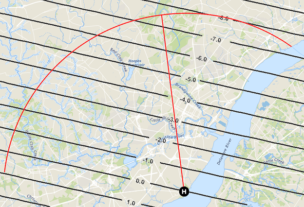
The above map shows the gradient of the magnetic declination over the area of the Taylor-Pierson survey in 1701. The gradient lines show declination in minutes relative to the declination at the Horse Dike - the 0.0 line shows all locations where a compass would read exactly the same as at the Horse Dike. Up at the end of the Due North Line, a magnetic compass would read 7½ minutes more westerly than it would have at the Horse Dike. An adjustment accounting for this gradient has been incorporated into the calculations for the Red Line so that it gives the same results that Taylor and Pierson would have seen on their own compass during the survey.
Due North Line
The following adjustments to the plan were incorporated to force the calculated Red Line to end so that the western arc runs through the north shore of the Brandywine at Big Bend and then through Hodgkins’s Kennett-Pennsbury point:
- Chaining was calculated with an overrun of 1.069%.
- The Due North Line was run at a bearing of 7.21°W. This was probably the magnetic declination in 1701.
Western Arc
The following adjustments to the plan were made to force the Red Line to
go through Hodgkins's Kennett-Pennsbury Point and then terminate at Briar
Creek ( in Fig. 37):
- Chaining was calculated with an overrun of 0.993%.
- An average compass error of -0.466′ was assumed, meaning each chord angle was increased by 59.534′ rather than the full 60′ (1°).
Eastern Arc
Both the Due North Line and the Western Arc have a known length, but the length of the Eastern Arc is uncertain. Taylor and Pierson found Nathaniel Lamply’s old house to be “at ye End of forty three Chords,” but it is unlikely that they found it at exactly forty-three chords from the White Oak. Their wording has been interpreted as indicating a point at or beyond forty-three chords, but still short of forty-four.[28]
Various combinations of chaining overrun and average compass errors can be used to model the Red Line along the Eastern Arc. Each combination gives a different number of chords but follows essentially the same path ending at Lamply’s. Here are three possible combinations yielding lengths between 43 and 44 chords:
| Chaining Overrun (%) |
Average Compass Error (minutes) |
Distance to Lamply’s (chords) |
| 2.382 | 0.543 | 43.00 |
| 1.000 | -1.406 | 43.59 |
| 0.038 | -1.930 | 44.00 |
Given that the chaining overrun was around 1% for the other two legs, it seems reasonable to assume a 1% chaining overrun on this leg as well. Therefore, the following adjustments were made to force the Red Line to terminate with a length of 43.59 chords at the location of Nathaniel Lamply’s house:
- Chaining was calculated with an overrun of 1.000%.
- An average compass error of -1.406′ was assumed, meaning each chord angle was increased by 58.594′ rather than the full 60′ (1°).
Conclusion
This study proposed a model Red Line that closely followed Taylor and Pierson’s plan. The model incorporated allowances for the surveying technologies of their time and was corroborated at multiple locations along the line through several forms of evidence.
The compass errors averaged out to well less than 2 minutes total error over the Eastern and Western Arcs. We can guesstimate the standard deviation for compass measurements was about ½ degree[29]. This is decent work for compasses of the time, especially considering the difficulty of making accurate measurements in the wilderness without the clearing of vistas as later surveyors did.
On all three legs, the chaining error was around a 1% overrun. This is not unreasonable given the hilly terrain that was involved.
Overall, this study finds that Isaac Taylor and Thomas Pierce did creditable work. They devised a practical plan for fulfilling Penn’s instructions and carried it out with reasonable accuracy despite the limitations of early eighteenth-century surveying technologies.
I would like to thank Paul Lagassé, Katie Clark, and Tim Barnekov for their research, insight, and suggestions.
Addendum: Hodgkins’s Critique
Nearly two centuries after Taylor and Pierson completed their work, and long after the “well-marked” trees had disappeared, there were concerns that no one really knew exactly where the Circular Line ran anymore. In 1889, Pennsylvania and Delaware appointed a boundary commission to “re-establish” the 1701 Circular Line, and William C. Hodgkins of the United States Coast and Geodetic Survey was engaged to lead it. For various reasons, Hodgkins and the commissioners did not re-establish the Circular Line but instead contrived a new compound Arc Boundary to replace it. At great expense, and before it was adopted by both states, this new boundary line was marked with forty-six “substantial” stone boundary markers.
This new boundary was controversial. There was sufficient folk memory of where the old line ran that, although people may not have agreed exactly where it was, they most emphatically knew that it did not run along the new line that Hodgkins had marked out. The matter was still being challenged in court when Hodgkins wrote his report in 1893.
These legal challenges may have put Hodgkins on the defensive and colored his account of Taylor and Pierson’s earlier work. He depicts them as rather hapless surveyors who wandered wildly off their intended course. Although some of his criticisms have merit, most of the discrepancies he identified stem from his own misunderstandings and from inadequate research, particularly on the part of the state appointed surveyors, who did not uncover the relevant patents at the western end of the Circular Line.
Hodgkins’s history/critique of the Taylor-Pierson survey[30] is reproduced below; his account, in italics, is interwoven with annotations to provide context and clarification.
In this same year, 1701, and perhaps in consequence of this legislative division of the provinces, the circular boundary line between Chester and Newcastle counties was run out upon the ground under a warrant from Penn. The work was done by Isaac Tailer [sic], of Chester County, and Thomas Pierson, of Newcastle County, under the direction of the county officials, in November, 1701. Their method of work is described in their field notes, which are in the possession of the Historical Society of Pennsylvania. (A)
| (A) | The Taylor-Pierson survey report was a fairly recent discovery when Hodgkins wrote this in 1893. Graham does not seem to have been aware of it when he did his work in 1849. The earliest mention I have found of it was in Futhey & Cope in their 1881 History of Chester County. Ashmead describes it in his 1884 History of Delaware County, but the usually thorough Scharf does not mention it in his 1888 History of Delaware. ↩ |
According to their record, they began work at "the end of the horse dike" (B) at Newcastle and ran a traverse to the northward with compass and chain until they reached a point which, from their computations, they supposed to be exactly 12 miles north of their starting point. By some mistake, however, they came out a mile or more too far to the west and about 2,000 feet too far from Newcastle (C). The excess in distance may have been due to their chain being too long, though the size of the error (2 feet to each chain} seems unlikely. This supposition is further borne out by the fact that the curve actually run out by them had, as nearly as can be ascertained, a radius of about 13 miles instead of 12 (D), as should have been the case. The excess of westing might be accounted for, by supposing that they used the magnetic meridian as their standard instead of the true north (E), but the declination of 8°30′ west, observed at Philadelphia in 1701 (F), would have carried them a half mile or more still farther to the west (G). It is very likely that their compass needle was a poor one (H) and that it was much affected by local attraction, which is very noticeable in the vicinity of the Brandywine (I). The extremity of the radius so determined fell upon land then occupied by a certain Israel Helm and now owned by one Goodley, in a peculiar bend formed by Brandywine Creek. Tailer and Pierson found there a white oak tree, which they marked with twelve notches. They next laid off a line at right angles to their supposed true radius and marked on it the distance corresponding to the chord of 1 degree of a circle of 12 miles radius. This distance they computed to be 67 perches, a value sufficiently precise for their purpose (more exactly, 67.018), but if, as seems likely, these measurements also overran, their chords were probably 68 or 69 perches in length (J).
| (B) | Despite noting that Taylor and Pierson's starting point for the Due North Line was at the end of the Horse Dike, Hodgkins does not seem to have figured out what or where the Horse Dike was. His criticism of Taylor and Pierson’s work assumes that their starting point was at the Court House, 1600 feet south-southwest of the Horse Dike (he may not have known that the Court House wasn't built until 31 years after Taylor and Pierson did their work). This erroneous assumption is a major component of Hodgkins’s misunderstanding of Taylor and Pierson’s work. ↩ | |||||
| (C) | Hodgkins’s claim that Taylor and Pierson ran their Due North Line “2,000 feet too far from Newcastle” is clearly excessive. Most of this difference is Hodgkins’s misunderstanding of the starting point, but, as noted previously, Taylor and Pierson did overrun this line by about 670 feet (1%). ↩ | |||||
| (D) | Hodgkins’s claim that Taylor and Pierson’s circle had a 13 mile radius is exaggerated. His own calculation of the radius of his Eastern Arc was 12.81 miles, but that arc was inflated by his team's misplacement of the Concord-Bethel point by 100 feet too far south. Taylor and Pierson’s circle had an apparent radius of 12.63 miles due to their 670 foot overrun of the Due North Line combined with overrunning the length of the chords by 1%. In any case, the apparent radius is not a valid means of assessing the accuracy of the measurement of the Due North Line since it is also a function of compass and chaining errors along the Circular Line. ↩ | |||||
| (E) | As previously discussed, Penn’s surveyors did not correct for magnetic declination, but simply followed the compass in their surveys, so Hodgkins is correct in his supposition that they used the magnetic meridian as their standard. ↩ | |||||
| (F) | Hodgkins does not cite a source for his 8°30′W figure, but for whatever it is worth, the IGRF model predicts 5°26′W for New Castle and 5°42′W for Philadelphia in 1701, a 16′ difference. ↩ | |||||
| (G) |
|
|||||
| (H) | The claim that their needle was a poor one is not born out by the previously discussed overall accuracy of the compass work on this survey. ↩ | |||||
| (I) | It is difficult to understand why a better needle would somehow be expected to be impervious to local magnetic variations. ↩ | |||||
| (J) | Hodgkins is correct in thinking that Taylor and Pierson’s chords ran long, but 68 or 69 perches per chord is a bit much. This study finds it most likely they overran by about 1%, or 67.7 perches. ↩ |
One-half of this chord was laid off on the east side of their radius and the other half to the west (K). Then, starting from the eastern end of the first chord, they ran the curve to the Delaware River by successive chords of 67 perches, making a uniform deflection to the right of 1 degree by compass at the end of each chord. Forty-three chords brought them to the Delaware, where they found that their line struck the north side of a house close to the shore, then occupied by one Daniel Lamplugh.
| (K) | Hodgkins’s claim that Taylor and Pierson laid out only half of a 1° chord on either side of the Due North Line is not supported by a literal reading of their report which suggests that full 1° chords were laid out. Neither implementation is mathematically correct since both result in these chords being right triangles rather than isosceles triangles. This results in radial distances slightly longer than 12 miles in subsequent chords. Hodgkins’s implementation is slightly better, but neither implementation results in significant errors[31] . ↩ |
The surveyors then retraced their steps to the farm of Israel Helm and in a precisely similar manner ran their curve to the westward from the first chord until they had completed 77 chords, which, together with the 43 chords east of their starting point, made up the total of 120 chords, or "two-thirds of a semicircle," called for by their instructions. They note that their line ended at a stream, a branch of Christina River, and that they "well marked" a hickory tree. This point can no longer be identified, but it was most likely in the present State of Maryland, to the westward or northwestward of the "triangular stone (L)" on the boundary between Delaware and Maryland. The stream referred to was probably one called Persimmon Creek on some recent maps (M). The course of the boundary line was indicated by notches cut in trees near which it ran.
| (L) | The “triangular stone”, now known as the Prism Stone, was erected by Graham in 1849 to mark what he thought to be the intersection point of the three states. Graham was unaware that the 1701 Circular Line (centered on the Horse Dike) was not the same as the Court House Circle used by Mason and Dixon. ↩ | |||||
| (M) |
|
It will be noticed that this boundary laid out by William Penn between two portions of his domain has no connection and little apparent relation to the boundary between the lands of Penn and those of Lord Baltimore, though subsequently complicated and confounded with the surveys of the latter line.
Although the line had been run out, little heed seems to have been given to it in the issue of patents for land. Over some small part of the boundary east of the Brandywine the patent lines were made to conform to the circular boundary, nominally at least, though it is noticeable that the old deeds pay no regard to the curvature of the line (N). The description of the bounds usually states that the line runs on a certain course a specified number of perches “along the circular boundary.”
| (N) | One such deed has been found. Delaware County Deed W.54 (1838) follows the 67 perch / 1 degree formula for the curvature, however the vertices do not seem to align with where Taylor and Pierson’s vertices would have been. ↩ |
Except in this one district the land patents pass over the boundary without reference to it. (O)
| (O) | Hodgkins and his two local surveyors did not adequately research land patents at the western end of the Circular Boundary. As has been previously discussed, the patent surveys for both the 1702 Joseph Moor Patent and the 1704 Alexander White Patent referenced the Circular Line within just a few years of it being surveyed. It is intriguing to consider how Hodgkins’s Arc Boundary Line might have differed had these two surveys been taken into account. ↩ |
So for years and generations this line slumbered in obscurity, perpetuated for a time in local memory and tradition by reference to oak or hickory trees blazed or notched by the surveyors or by fences which some settler had built, as he supposed, upon the line. But year by year these witness marks decayed and passed from sight, until their very location became uncertain and until it has come to pass that at the present time the tolerably authentic relics of the old survey may be counted upon the fingers of one hand.
Unfortunately, Hodgkins’s condescending portrayal of Taylor and Pierson’s work
has been echoed in subsequent histories by other writers. This study
has aimed to correct the record and offer a more balanced perspective on
Taylor and Pierson’s work.
List Of Figures
| Figure 1 | Evidence of the original Circular Line. Basemap: USGS National Map. ↩ |
| Figure 2 | The Isosceles Triangle. ↩ |
| Figure 3 | An Approximation of the Circular Line. ↩ |
| Figure 4 | Surveying Chain. Courtesy of John Starzmann. This particular chain measured 66 ft 8¼” - almost 1% too long - with no apparent way to adjust it. Could this somehow be the one used by Taylor and Pierson? ↩ |
| Figure 5 | Potential Deviations Due To Chaining Errors. ↩ |
| Figure 6 | Compass Face. Unknown author, Public domain, via Wikimedia Commons. ↩ |
| Figure 7 | Deviations due to Systematic Compass Errors. ↩ |
| Figure 8 | The Starting Point for the Taylor-Pierson Survey. ↩ |
| Figure 9 | Points of interest along the Due North Line. Left: Isaac Taylor and Taylor Pierson, The Figure of the Circular Line Dividing Between the County of New Castle & County of Chester. (1701) Detail Map. Mason-Dixon Line papers [Am.2349 ID18096], Collection of the Historical Society of Pennsylvania. Right: Modern Map. ↩ |
| Figure 10 | Two points along the Brandywine, Taylor-Pierson detail. ↩ |
| Figure 11 | Two points along the Brandywine, modern map. ↩ |
| Figure 12 | Due North Line terminus, Taylor-Pierson detail. ↩ |
| Figure 13 | Due North Line terminus, modern map. ↩ |
| Figure 14 | Beaver Creek, Taylor-Pierson detail. ↩ |
| Figure 15 | Beaver Creek, Basemaps: USGS Nation Map, USGS Hydro ↩ |
| Figure 16 | Hodgkins's Concord-Bethel Point and the Tall Hickory. Basemap: USGS National Map.' ↩ |
| Figure 17 | 1775 William Burnett Tract. ↩ |
| Figure 18 | 1685 Thomas Holme Map. ↩ |
| Figure 19 | Concord Township in 1848, Ash, Joshua W, Gustavus Kramm, and Robert Pearsall Smith. Map of Delaware County, Pennsylvania: from original surveys, with the farm limits. Philadelphia: Published by Robert P. Smith, 1848. Map. https://www.loc.gov/item/2012592172/. ↩ |
| Figure 20 | The Burnett Tract in 1848, Ash, etc. Detail Map ↩ |
| Figure 21 | Southern boundary of the Burnett Tract. Basemap: USGS National Map. ↩ |
| Figure 22 | 1702 Nathaniel Newlin Tract. ↩ |
| Figure 23 | 1750 Robert Green Tract. ↩ |
| Figure 24 | 1750 Robert Green Tract on modern map. ↩ |
| Figure 25 | Terminus of Eastern Arc, Taylor-Pierson detail. ↩ |
| Figure 26 | Terminus of Eastern Arc, modern map. Basemap: USGS National Map. ↩ |
| Figure 27 | East Branch of the Christina, Taylor-Pierson Detail. ↩ |
| Figure 28 | East Branch of the Christina, modern map. Basemap: USGS National Map. ↩ |
| Figure 29 | 1702 Joseph Moor Survey, Courtesy of the Delaware Public Archives New Castle County, Recorder of Deeds, Warrants and Surveys, Folder M 2, #26;2555-000-016, Box 353838, Delaware Public Archives, Dover, DE. ↩ |
| Figure 30 | Moor Survey on modern map. Basemap: USGS National Map. ↩ |
| Figure 31 | 1704 Alexander White Survey. Courtesy of the Historical Society of Pennsylvania. ↩ |
| Figure 32 | Alexander White Tract on a modern map. Basemap: USGS National Map. ↩ |
| Figure 33 | Convergence Point near the South end of the Circular Line. Basemap: USGS National Map ↩ |
| Figure 34 | Elevation Profile along the Circular Line ↩ |
| Figure 35 | Hickery at the Terminus of Western Arc. Taylor-Pierson Detail. ↩ |
| Figure 36 | Terminus of Western Arc on 1898 Topographic Map. ↩ |
| Figure 37 | Terminus on modern map. ↩ |
| Figure 38 | Gradient of Magnetic Declination relative to the Horse Dike. Basemap: Open Street Map Basic, USGS Hydro Layer. Magnetic declination data: NOAA mag declination calculator https://www.ngdc.noaa.gov/geomag/calculators/magcalc.shtml. ↩ |
| Figure 39 | Two Lines Running at a 8°30′W bearing, one from the Court House and the other from the Horse Dike ↩ |
| Figure 40 | Persimmon Creek relative to the end of the Taylor-Pierson Circular Line. ↩ |
References
| [1] | William Penn's Warrant for the Taylor-Pierson Survey, reproduced in William C. Hodgkins, “Part I.-A Historical Account of the Boundary Line Betweenthe States of Pennsylvania and Delaware”, in Report of the Superintendent of the U. S. Coast and Geodetic Survey for the Fiscal Year Ending June 30, 1893: Part II (Washington, D.C., Government Printing Office, 1893), after p. 186. ↩ |
| [2] | Taylor-Pierson Survey transcriptions courtesy of Paul Legassé. ↩ |
| [3] | John Thomas Scharf, History of Delaware: 1609-1888, L. J. Richards & Co., 1888, Vol. II, pp. 860-861. ↩ |
| [4] | “Early Boundary Surveys True, So Says Engineer Kimmey in Replying to Historian Hayes,”Evening Journal (Wilmington, DE), June 20, 1920, p. 11. ↩ |
| [5] | The Broad Dyke Historical Marker is about 150 feet away in New Castle’s Veterans Triangle Park. ↩ |
| [6] | For the purposes of this article, Taylor and Pierson’s survey map has been reoriented so that true north is at the top. ↩ |
| [7] | William C. Hodgkins, “Part I.-A Historical Account of the Boundary Line Betweenthe States of Pennsylvania and Delaware”, in Report of the Superintendent of the U. S. Coast and Geodetic Survey for the Fiscal Year Ending June 30, 1893: Part II (Washington, D.C., Government Printing Office, 1893), p. 200. ↩ |
| [8] | Hodgkins, p. 204. ↩ |
| [9] | Chester County Deed Book T, p. 523 ↩ |
| [10] | This measurement of 378 perches was confirmed in two later surveys on the other side of the township line in Bethel township using the same White and Black Oaks. In 1789 a portion of this line was measured to be 158 perches (Delaware County Deed Book L, p. 388), and the following year the remainder of the line was measured to be 220 perches (Delaware County Deed Book D, p. 45). ↩ |
| [11] | Philadelphia Patent Book A, vol 2, page 261, as recited in Chester County Deed Book P, p. 307. ↩ |
| [12] | Chester County Deed Book P, p. 307. ↩ |
| [13] | Delaware County Deed Book R, p. 725 ↩ |
| [14] | This length was re-confirmed in a 1759 survey (Chester County Deed Book L, p. 438). ↩ |
| [15] | This leg was resurveyed in 1810 and found to be 153 perches long (Delaware County Deeds Book I, p. 627). It was resurveyed again in 1838 and found to be 154.5 perches long (Delaware County Deed Book W, p. 54). These three measurements are within 25 ft of each other. ↩ |
| [16] | Mathematically, three points define a circle. The other two points, Kennett-Pennsbury and the Ruins, are undisputed by this study. ↩ |
| [17] | Hodgkins, p. 204. ↩ |
| [18] | Chester County Deed Book D, p. 60. ↩ |
| [19] | Hodgkins, p. 200. ↩ |
| [20] | “The State Boundary Line … A Victory for John T. Johnson,” Delaware Gazette and State Journal (Wilmington, DE), February 18, 1897, p. 1. Johnson’sresidence was located in what is now the south-east corner of London BritainTownship. ↩ |
| [21] | Rea, Samuel M, Jacob Price, George Read Riddle, Robert Pearsall Smith, Smith & Wistar, and Rea & Price. Map of New Castle County, Delaware:from original surveys. Philadelphia: Smith & Wistar, 1849. Map. https://www.loc.gov/item/2013593084/. ↩ |
| [22] | G.M. Hopkins & Co, Griffith Morgan Hopkins, F Bourquin, and Walter S. Mac Cormac & Co. Map of New Castle County, Delaware: from actual surveys & records. Philadelphia: G.M. Hopkins & Co, 1881. Map. https://www.loc.gov/item/2013593083/. ↩ |
| [23] | Elevation data from USGS National Map - Elevation Point Query Service:https://apps.nationalmap.gov/epqs/ ↩ |
| [24] | Taylor and Pierson stopped their survey at the Hickery. For this graph, the path of the Circular Line has been mathematically extrapolated on down to slightly beyond Persimmon Creek. ↩ |
| [25] | https://de-firstmap-delaware.hub.arcgis.com/datasets/delaware::delaware-boundaries/explore?layer=0&location=39.145250%2C-75.387000%2C7 ↩ |
| [26] | https://opendata.firstmap.delaware.gov/datasets/delaware::delaware-boundaries/explore?layer=0 ↩ |
| [27] | A magnetic declination calculator, including the IGRF model, is available atf NOAA's website: https://www.ngdc.noaa.gov/geomag/calculators/magcalc.shtml ↩ |
| [28] | It was unnecessary, under Penn’s warrant, to determine an exact distance to the river shore. The only requirement was surveying at least 120 chords, and the Eastern Arc supplied forty-three of those (and then some). ↩ |
| [29] | Statistically, this is the standard error of the mean. The worst average compass error seen was 1.4 minutes for the eastern arc. Guessing that it took four compass readings for each of the 120 chords due to the trees, then the standard deviation for each compass reading would be around 30 minutes, or ½ a degree. ↩ |
| [30] | Hodgkins, pp, 185-187. ↩ |
| [31] | Hodgkin's implementation would increase the radial distance by 2.4 ft, Taylor and Pierson's implementation increased it by 9.6 ft. ↩ |